You are here: Home > Network List > TA - USArray Transportable Network (new EarthScope stations) Stations List
> Station R16A Teasdale, UT, USA > Earthquake Result Viewer
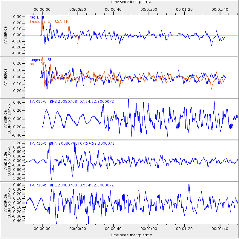
R16A Teasdale, UT, USA - Earthquake Result Viewer
*The percent match for this event was below the threshold and hence no stack was calculated.
| Earthquake location: |
Ryukyu Islands, Japan |
| Earthquake latitude/longitude: |
27.5/128.3 |
| Earthquake time(UTC): |
2008/07/08 (190) 07:42:10 GMT |
| Earthquake Depth: |
43 km |
| Earthquake Magnitude: |
6.0 MB, 5.5 MS, 6.0 MW, 6.0 MW |
| Earthquake Catalog/Contributor: |
WHDF/NEIC |
|
| Network: |
TA USArray Transportable Network (new EarthScope stations) |
| Station: |
R16A Teasdale, UT, USA |
| Lat/Lon: |
38.28 N/111.48 W |
| Elevation: |
2202 m |
|
| Distance: |
93.9 deg |
| Az: |
42.987 deg |
| Baz: |
309.701 deg |
| Ray Param: |
$rayparam |
*The percent match for this event was below the threshold and hence was not used in the summary stack. |
|
| Radial Match: |
63.47109 % |
| Radial Bump: |
400 |
| Transverse Match: |
66.339554 % |
| Transverse Bump: |
400 |
| SOD ConfigId: |
2504 |
| Insert Time: |
2010-03-06 14:58:26.836 +0000 |
| GWidth: |
2.5 |
| Max Bumps: |
400 |
| Tol: |
0.001 |
|
Signal To Noise
| Channel | StoN | STA | LTA |
| TA:R16A: :BHN:20080708T07:54:52.300007Z | 3.5823824 | 4.5112256E-7 | 1.2592808E-7 |
| TA:R16A: :BHE:20080708T07:54:52.300007Z | 0.95800203 | 1.2443373E-7 | 1.2988879E-7 |
| TA:R16A: :BHZ:20080708T07:54:52.300007Z | 1.1963013 | 1.4045786E-7 | 1.17410096E-7 |
| Arrivals |
| Ps | |
| PpPs | |
| PsPs/PpSs | |


