You are here: Home > Network List > AK - Alaska Regional Network Stations List
> Station RKAV Rock Avalanche, AK, USA > Earthquake Result Viewer
RKAV Rock Avalanche, AK, USA - Earthquake Result Viewer
| Earthquake location: |
Southeast Of Loyalty Islands |
| Earthquake latitude/longitude: |
-22.2/170.0 |
| Earthquake time(UTC): |
2018/08/29 (241) 03:51:55 GMT |
| Earthquake Depth: |
10 km |
| Earthquake Magnitude: |
7.0 Mi |
| Earthquake Catalog/Contributor: |
NEIC PDE/pt |
|
| Network: |
AK Alaska Regional Network |
| Station: |
RKAV Rock Avalanche, AK, USA |
| Lat/Lon: |
60.30 N/141.35 W |
| Elevation: |
1647 m |
|
| Distance: |
91.2 deg |
| Az: |
21.966 deg |
| Baz: |
224.121 deg |
| Ray Param: |
0.041619387 |
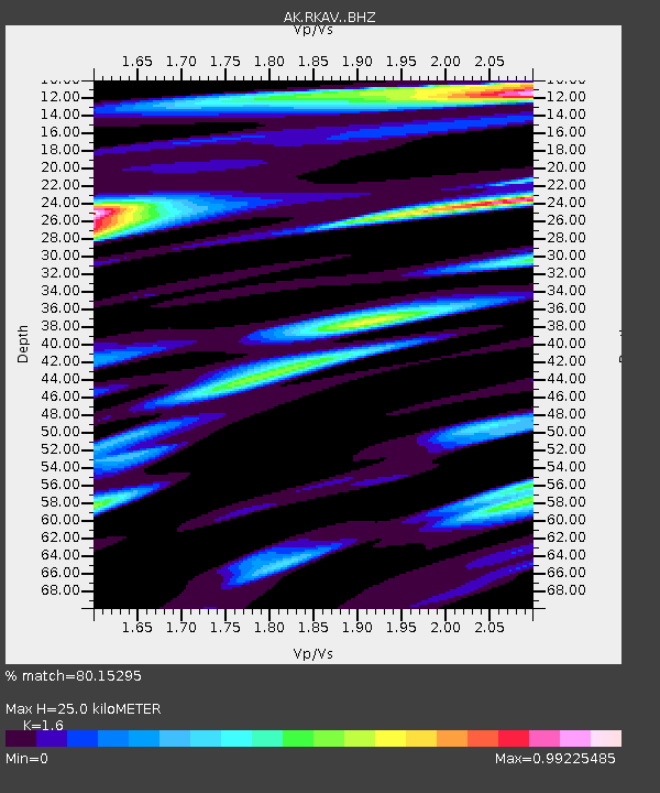
| Estimated Moho Depth: |
25.0 km |
| Estimated Crust Vp/Vs: |
1.60 |
| Assumed Crust Vp: |
6.566 km/s |
| Estimated Crust Vs: |
4.104 km/s |
| Estimated Crust Poisson's Ratio: |
0.18 |
|
| Radial Match: |
80.15295 % |
| Radial Bump: |
400 |
| Transverse Match: |
49.822548 % |
| Transverse Bump: |
400 |
| SOD ConfigId: |
13570011 |
| Insert Time: |
2019-05-01 01:07:58.379 +0000 |
| GWidth: |
2.5 |
| Max Bumps: |
400 |
| Tol: |
0.001 |
|

Signal To Noise
| Channel | StoN | STA | LTA |
| AK:RKAV: :BHZ:20180829T04:04:27.427979Z | 3.6667554 | 1.0209667E-6 | 2.784387E-7 |
| AK:RKAV: :BHN:20180829T04:04:27.427979Z | 1.1781592 | 4.3636624E-7 | 3.703797E-7 |
| AK:RKAV: :BHE:20180829T04:04:27.427979Z | 1.7769991 | 4.410093E-7 | 2.4817643E-7 |
| Arrivals |
| Ps | 2.3 SECOND |
| PpPs | 9.7 SECOND |
| PsPs/PpSs | 12 SECOND |


