You are here: Home > Network List > AK - Alaska Regional Network Stations List
> Station SII Sitkinak Island Coast Guard > Earthquake Result Viewer
SII Sitkinak Island Coast Guard - Earthquake Result Viewer
| Earthquake location: |
Southeast Of Loyalty Islands |
| Earthquake latitude/longitude: |
-22.2/170.0 |
| Earthquake time(UTC): |
2018/08/29 (241) 03:51:55 GMT |
| Earthquake Depth: |
10 km |
| Earthquake Magnitude: |
7.0 Mi |
| Earthquake Catalog/Contributor: |
NEIC PDE/pt |
|
| Network: |
AK Alaska Regional Network |
| Station: |
SII Sitkinak Island Coast Guard |
| Lat/Lon: |
56.56 N/154.18 W |
| Elevation: |
465 m |
|
| Distance: |
84.1 deg |
| Az: |
19.021 deg |
| Baz: |
213.064 deg |
| Ray Param: |
0.045739003 |
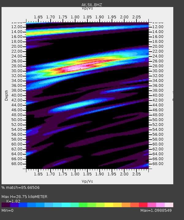
| Estimated Moho Depth: |
28.75 km |
| Estimated Crust Vp/Vs: |
1.82 |
| Assumed Crust Vp: |
6.24 km/s |
| Estimated Crust Vs: |
3.429 km/s |
| Estimated Crust Poisson's Ratio: |
0.28 |
|
| Radial Match: |
85.66506 % |
| Radial Bump: |
400 |
| Transverse Match: |
78.21089 % |
| Transverse Bump: |
400 |
| SOD ConfigId: |
13570011 |
| Insert Time: |
2019-05-01 01:08:03.111 +0000 |
| GWidth: |
2.5 |
| Max Bumps: |
400 |
| Tol: |
0.001 |
|

Signal To Noise
| Channel | StoN | STA | LTA |
| AK:SII: :BHZ:20180829T04:03:53.14801Z | 6.9528894 | 3.084351E-6 | 4.436071E-7 |
| AK:SII: :BHN:20180829T04:03:53.14801Z | 2.0891235 | 1.2360564E-6 | 5.916626E-7 |
| AK:SII: :BHE:20180829T04:03:53.14801Z | 1.8599377 | 9.795173E-7 | 5.2663984E-7 |
| Arrivals |
| Ps | 3.9 SECOND |
| PpPs | 13 SECOND |
| PsPs/PpSs | 17 SECOND |


