You are here: Home > Network List > AU - Australian Seismological Centre Stations List
> Station WB2 Warramunga Array, Australia > Earthquake Result Viewer
WB2 Warramunga Array, Australia - Earthquake Result Viewer
| Earthquake location: |
Southeast Of Loyalty Islands |
| Earthquake latitude/longitude: |
-22.2/170.0 |
| Earthquake time(UTC): |
2018/08/29 (241) 03:51:55 GMT |
| Earthquake Depth: |
10 km |
| Earthquake Magnitude: |
7.0 Mi |
| Earthquake Catalog/Contributor: |
NEIC PDE/pt |
|
| Network: |
AU Australian Seismological Centre |
| Station: |
WB2 Warramunga Array, Australia |
| Lat/Lon: |
19.94 S/134.35 E |
| Elevation: |
388 m |
|
| Distance: |
33.3 deg |
| Az: |
267.167 deg |
| Baz: |
100.27 deg |
| Ray Param: |
0.07828265 |
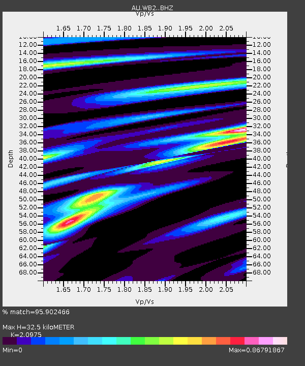
| Estimated Moho Depth: |
32.5 km |
| Estimated Crust Vp/Vs: |
2.10 |
| Assumed Crust Vp: |
6.642 km/s |
| Estimated Crust Vs: |
3.167 km/s |
| Estimated Crust Poisson's Ratio: |
0.35 |
|
| Radial Match: |
95.902466 % |
| Radial Bump: |
194 |
| Transverse Match: |
75.747505 % |
| Transverse Bump: |
400 |
| SOD ConfigId: |
13570011 |
| Insert Time: |
2019-05-01 01:08:29.727 +0000 |
| GWidth: |
2.5 |
| Max Bumps: |
400 |
| Tol: |
0.001 |
|

Signal To Noise
| Channel | StoN | STA | LTA |
| AU:WB2: :BHZ:20180829T03:58:02.200012Z | 3.7588089 | 1.145143E-6 | 3.0465583E-7 |
| AU:WB2: :BHN:20180829T03:58:02.200012Z | 1.3784342 | 2.6751445E-7 | 1.9407126E-7 |
| AU:WB2: :BHE:20180829T03:58:02.200012Z | 2.5573504 | 6.7293865E-7 | 2.63139E-7 |
| Arrivals |
| Ps | 5.8 SECOND |
| PpPs | 14 SECOND |
| PsPs/PpSs | 20 SECOND |


