You are here: Home > Network List > CC - Cascade Chain Volcano Monitoring Stations List
> Station PR05 Puyallup River 05 > Earthquake Result Viewer
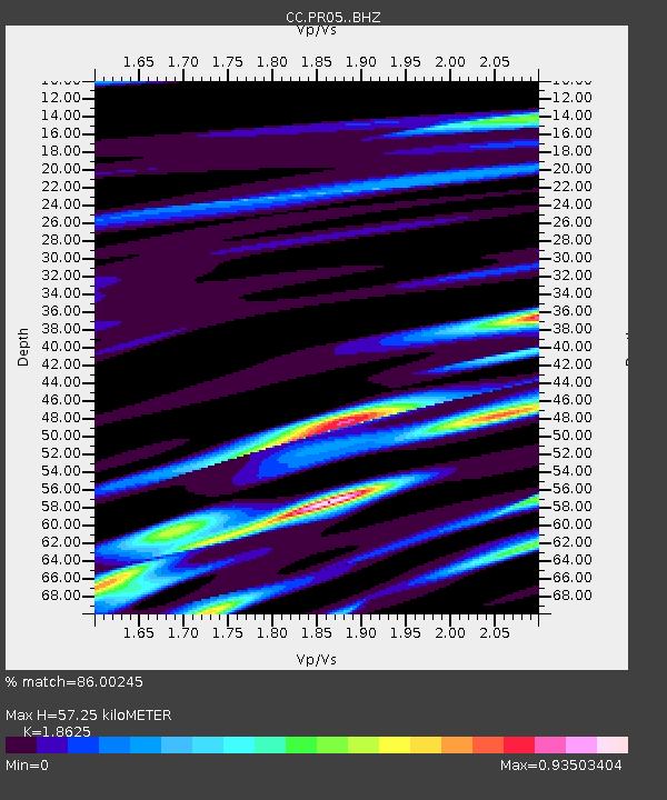
PR05 Puyallup River 05 - Earthquake Result Viewer
| Earthquake location: |
Southeast Of Loyalty Islands |
| Earthquake latitude/longitude: |
-22.2/170.0 |
| Earthquake time(UTC): |
2018/08/29 (241) 03:51:55 GMT |
| Earthquake Depth: |
10 km |
| Earthquake Magnitude: |
7.0 Mi |
| Earthquake Catalog/Contributor: |
NEIC PDE/pt |
|
| Network: |
CC Cascade Chain Volcano Monitoring |
| Station: |
PR05 Puyallup River 05 |
| Lat/Lon: |
46.84 N/121.95 W |
| Elevation: |
1553 m |
|
| Distance: |
92.0 deg |
| Az: |
39.584 deg |
| Baz: |
239.353 deg |
| Ray Param: |
0.041519556 |
| Estimated Moho Depth: |
57.25 km |
| Estimated Crust Vp/Vs: |
1.86 |
| Assumed Crust Vp: |
6.597 km/s |
| Estimated Crust Vs: |
3.542 km/s |
| Estimated Crust Poisson's Ratio: |
0.30 |
|
| Radial Match: |
86.00245 % |
| Radial Bump: |
400 |
| Transverse Match: |
69.98122 % |
| Transverse Bump: |
400 |
| SOD ConfigId: |
13570011 |
| Insert Time: |
2019-05-01 01:10:04.149 +0000 |
| GWidth: |
2.5 |
| Max Bumps: |
400 |
| Tol: |
0.001 |
|

Signal To Noise
| Channel | StoN | STA | LTA |
| CC:PR05: :BHZ:20180829T04:04:31.299988Z | 8.289951 | 8.963595E-7 | 1.08126024E-7 |
| CC:PR05: :BHN:20180829T04:04:31.299988Z | 1.7525512 | 2.9211736E-7 | 1.6668123E-7 |
| CC:PR05: :BHE:20180829T04:04:31.299988Z | 2.9890487 | 4.3075732E-7 | 1.4411184E-7 |
| Arrivals |
| Ps | 7.6 SECOND |
| PpPs | 24 SECOND |
| PsPs/PpSs | 32 SECOND |


