You are here: Home > Network List > NM - Cooperative New Madrid Seismic Network Stations List
> Station CLTN Cedars of Lebanon,TN > Earthquake Result Viewer
CLTN Cedars of Lebanon,TN - Earthquake Result Viewer
| Earthquake location: |
Near Coast Of Ecuador |
| Earthquake latitude/longitude: |
0.6/-79.6 |
| Earthquake time(UTC): |
2016/07/11 (193) 02:01:09 GMT |
| Earthquake Depth: |
14 km |
| Earthquake Magnitude: |
5.8 MWW, 5.7 MWB, 5.9 MWC |
| Earthquake Catalog/Contributor: |
NEIC PDE/NEIC COMCAT |
|
| Network: |
NM Cooperative New Madrid Seismic Network |
| Station: |
CLTN Cedars of Lebanon,TN |
| Lat/Lon: |
36.09 N/86.33 W |
| Elevation: |
208 m |
|
| Distance: |
35.9 deg |
| Az: |
350.741 deg |
| Baz: |
168.543 deg |
| Ray Param: |
0.07697397 |
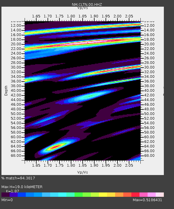
| Estimated Moho Depth: |
19.0 km |
| Estimated Crust Vp/Vs: |
1.87 |
| Assumed Crust Vp: |
6.444 km/s |
| Estimated Crust Vs: |
3.446 km/s |
| Estimated Crust Poisson's Ratio: |
0.30 |
|
| Radial Match: |
94.3817 % |
| Radial Bump: |
251 |
| Transverse Match: |
72.10435 % |
| Transverse Bump: |
400 |
| SOD ConfigId: |
1634031 |
| Insert Time: |
2016-07-25 02:12:17.941 +0000 |
| GWidth: |
2.5 |
| Max Bumps: |
400 |
| Tol: |
0.001 |
|

Signal To Noise
| Channel | StoN | STA | LTA |
| NM:CLTN:00:HHZ:20160711T02:07:38.07501Z | 12.414422 | 9.139573E-7 | 7.3620605E-8 |
| NM:CLTN:00:HHN:20160711T02:07:38.07501Z | 11.41513 | 6.156501E-7 | 5.393282E-8 |
| NM:CLTN:00:HHE:20160711T02:07:38.07501Z | 4.9389014 | 2.0124578E-7 | 4.0747075E-8 |
| Arrivals |
| Ps | 2.8 SECOND |
| PpPs | 7.9 SECOND |
| PsPs/PpSs | 11 SECOND |


