You are here: Home > Network List > NN - Western Great Basin/Eastern Sierra Nevada Stations List
> Station CTC N. Tahoe City Carnelian Bay > Earthquake Result Viewer
CTC N. Tahoe City Carnelian Bay - Earthquake Result Viewer
| Earthquake location: |
Southeast Of Loyalty Islands |
| Earthquake latitude/longitude: |
-22.2/170.0 |
| Earthquake time(UTC): |
2018/08/29 (241) 03:51:55 GMT |
| Earthquake Depth: |
10 km |
| Earthquake Magnitude: |
7.0 Mi |
| Earthquake Catalog/Contributor: |
NEIC PDE/pt |
|
| Network: |
NN Western Great Basin/Eastern Sierra Nevada |
| Station: |
CTC N. Tahoe City Carnelian Bay |
| Lat/Lon: |
39.21 N/120.13 W |
| Elevation: |
2147 m |
|
| Distance: |
89.4 deg |
| Az: |
46.857 deg |
| Baz: |
240.507 deg |
| Ray Param: |
0.041903827 |
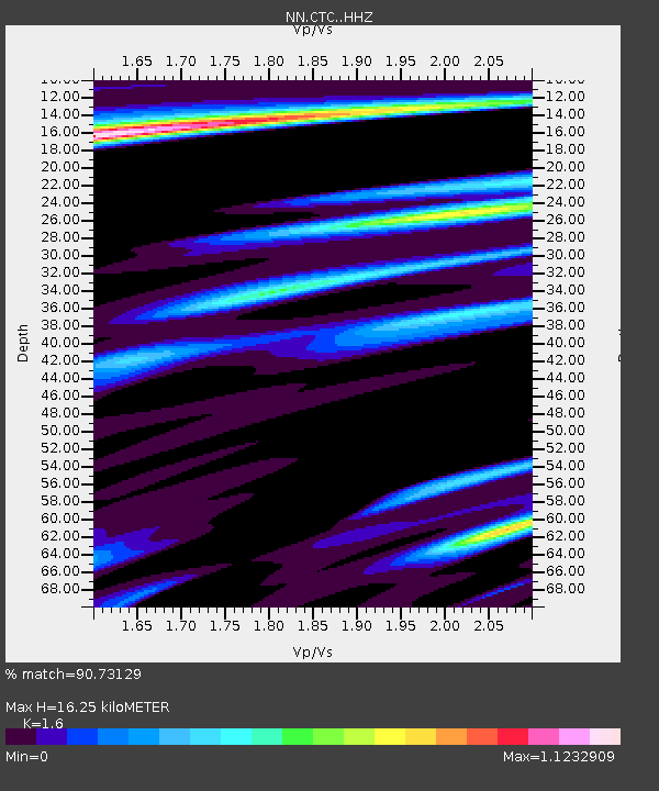
| Estimated Moho Depth: |
16.25 km |
| Estimated Crust Vp/Vs: |
1.60 |
| Assumed Crust Vp: |
6.597 km/s |
| Estimated Crust Vs: |
4.123 km/s |
| Estimated Crust Poisson's Ratio: |
0.18 |
|
| Radial Match: |
90.73129 % |
| Radial Bump: |
400 |
| Transverse Match: |
77.78608 % |
| Transverse Bump: |
400 |
| SOD ConfigId: |
13570011 |
| Insert Time: |
2019-05-01 01:12:13.829 +0000 |
| GWidth: |
2.5 |
| Max Bumps: |
400 |
| Tol: |
0.001 |
|

Signal To Noise
| Channel | StoN | STA | LTA |
| NN:CTC: :HHZ:20180829T04:04:18.968018Z | 16.938824 | 1.3127265E-6 | 7.749809E-8 |
| NN:CTC: :HHN:20180829T04:04:18.968018Z | 2.49815 | 2.6456664E-7 | 1.0590502E-7 |
| NN:CTC: :HHE:20180829T04:04:18.968018Z | 4.603264 | 4.8693624E-7 | 1.0578065E-7 |
| Arrivals |
| Ps | 1.5 SECOND |
| PpPs | 6.2 SECOND |
| PsPs/PpSs | 7.8 SECOND |


