You are here: Home > Network List > TA - USArray Transportable Network (new EarthScope stations) Stations List
> Station R16A Teasdale, UT, USA > Earthquake Result Viewer
R16A Teasdale, UT, USA - Earthquake Result Viewer
*The percent match for this event was below the threshold and hence no stack was calculated.
| Earthquake location: |
Vanuatu Islands |
| Earthquake latitude/longitude: |
-14.9/168.1 |
| Earthquake time(UTC): |
2008/11/07 (312) 09:40:00 GMT |
| Earthquake Depth: |
10 km |
| Earthquake Magnitude: |
5.5 MB, 4.9 MS, 5.5 MW |
| Earthquake Catalog/Contributor: |
WHDF/NEIC |
|
| Network: |
TA USArray Transportable Network (new EarthScope stations) |
| Station: |
R16A Teasdale, UT, USA |
| Lat/Lon: |
38.28 N/111.48 W |
| Elevation: |
2202 m |
|
| Distance: |
91.8 deg |
| Az: |
50.924 deg |
| Baz: |
252.48 deg |
| Ray Param: |
$rayparam |
*The percent match for this event was below the threshold and hence was not used in the summary stack. |
|
| Radial Match: |
78.99902 % |
| Radial Bump: |
400 |
| Transverse Match: |
71.68697 % |
| Transverse Bump: |
400 |
| SOD ConfigId: |
2658 |
| Insert Time: |
2010-03-06 14:59:18.449 +0000 |
| GWidth: |
2.5 |
| Max Bumps: |
400 |
| Tol: |
0.001 |
|
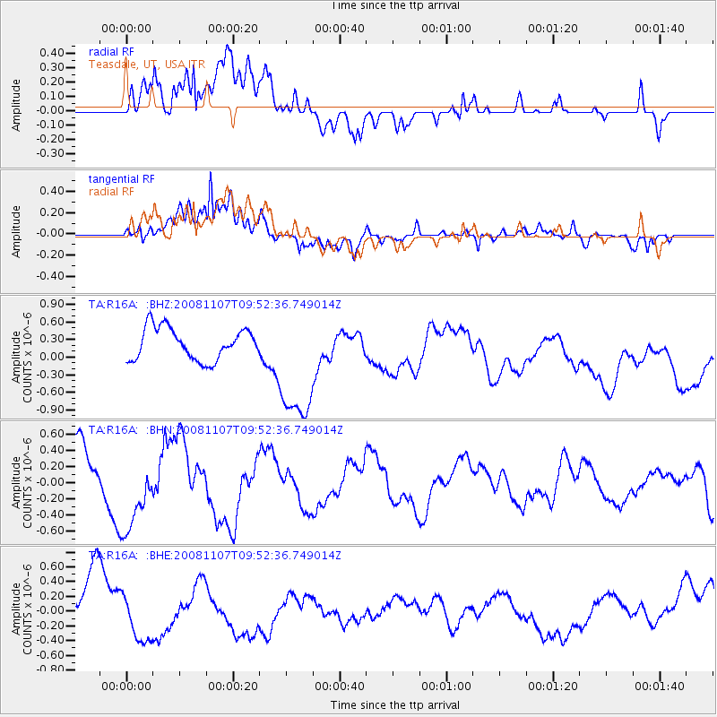
Signal To Noise
| Channel | StoN | STA | LTA |
| TA:R16A: :BHN:20081107T09:52:36.749014Z | 1.1031873 | 5.0676425E-7 | 4.5936372E-7 |
| TA:R16A: :BHE:20081107T09:52:36.749014Z | 0.981739 | 3.2133931E-7 | 3.2731646E-7 |
| TA:R16A: :BHZ:20081107T09:52:36.749014Z | 3.9878337 | 1.0783299E-6 | 2.704049E-7 |
| Arrivals |
| Ps | |
| PpPs | |
| PsPs/PpSs | |


