You are here: Home > Network List > TA - USArray Transportable Network (new EarthScope stations) Stations List
> Station C21K Knifeblade Ridge, AK, USA > Earthquake Result Viewer
C21K Knifeblade Ridge, AK, USA - Earthquake Result Viewer
| Earthquake location: |
Southeast Of Loyalty Islands |
| Earthquake latitude/longitude: |
-22.2/170.0 |
| Earthquake time(UTC): |
2018/08/29 (241) 03:51:55 GMT |
| Earthquake Depth: |
10 km |
| Earthquake Magnitude: |
7.0 Mi |
| Earthquake Catalog/Contributor: |
NEIC PDE/pt |
|
| Network: |
TA USArray Transportable Network (new EarthScope stations) |
| Station: |
C21K Knifeblade Ridge, AK, USA |
| Lat/Lon: |
69.16 N/154.78 W |
| Elevation: |
409 m |
|
| Distance: |
94.6 deg |
| Az: |
11.957 deg |
| Baz: |
212.445 deg |
| Ray Param: |
0.041012432 |
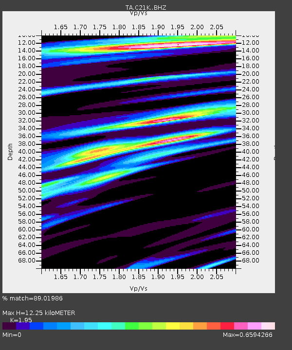
| Estimated Moho Depth: |
12.25 km |
| Estimated Crust Vp/Vs: |
1.95 |
| Assumed Crust Vp: |
6.221 km/s |
| Estimated Crust Vs: |
3.19 km/s |
| Estimated Crust Poisson's Ratio: |
0.32 |
|
| Radial Match: |
89.01986 % |
| Radial Bump: |
400 |
| Transverse Match: |
76.81775 % |
| Transverse Bump: |
400 |
| SOD ConfigId: |
13570011 |
| Insert Time: |
2019-05-01 01:13:27.968 +0000 |
| GWidth: |
2.5 |
| Max Bumps: |
400 |
| Tol: |
0.001 |
|

Signal To Noise
| Channel | StoN | STA | LTA |
| TA:C21K: :BHZ:20180829T04:04:42.950012Z | 10.300522 | 1.0234634E-6 | 9.9360335E-8 |
| TA:C21K: :BHN:20180829T04:04:42.950012Z | 3.3353298 | 2.5308572E-7 | 7.5880266E-8 |
| TA:C21K: :BHE:20180829T04:04:42.950012Z | 1.5528343 | 1.25392E-7 | 8.075041E-8 |
| Arrivals |
| Ps | 1.9 SECOND |
| PpPs | 5.7 SECOND |
| PsPs/PpSs | 7.6 SECOND |


