You are here: Home > Network List > TA - USArray Transportable Network (new EarthScope stations) Stations List
> Station O15A The Old Anderson's Place, Rush Valley, UT, USA > Earthquake Result Viewer
O15A The Old Anderson's Place, Rush Valley, UT, USA - Earthquake Result Viewer
| Earthquake location: |
North Of Svalbard |
| Earthquake latitude/longitude: |
80.3/-1.9 |
| Earthquake time(UTC): |
2009/03/06 (065) 10:50:29 GMT |
| Earthquake Depth: |
9.0 km |
| Earthquake Magnitude: |
6.6 MB, 6.5 MS, 6.5 MW, 6.4 MW |
| Earthquake Catalog/Contributor: |
WHDF/NEIC |
|
| Network: |
TA USArray Transportable Network (new EarthScope stations) |
| Station: |
O15A The Old Anderson's Place, Rush Valley, UT, USA |
| Lat/Lon: |
40.28 N/112.47 W |
| Elevation: |
1611 m |
|
| Distance: |
53.9 deg |
| Az: |
297.607 deg |
| Baz: |
11.301 deg |
| Ray Param: |
0.06579046 |
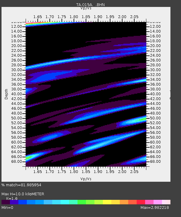
| Estimated Moho Depth: |
10.0 km |
| Estimated Crust Vp/Vs: |
1.60 |
| Assumed Crust Vp: |
6.276 km/s |
| Estimated Crust Vs: |
3.922 km/s |
| Estimated Crust Poisson's Ratio: |
0.18 |
|
| Radial Match: |
81.985954 % |
| Radial Bump: |
400 |
| Transverse Match: |
85.17969 % |
| Transverse Bump: |
400 |
| SOD ConfigId: |
2658 |
| Insert Time: |
2010-03-06 14:59:22.300 +0000 |
| GWidth: |
2.5 |
| Max Bumps: |
400 |
| Tol: |
0.001 |
|

Signal To Noise
| Channel | StoN | STA | LTA |
| TA:O15A: :BHN:20090306T10:59:21.975002Z | 57.291794 | 5.797468E-6 | 1.01191944E-7 |
| TA:O15A: :BHE:20090306T10:59:21.975002Z | 17.676321 | 4.9329465E-6 | 2.790709E-7 |
| TA:O15A: :BHZ:20090306T10:59:21.975002Z | 8.171607 | 3.878323E-6 | 4.7460952E-7 |
| Arrivals |
| Ps | 1.0 SECOND |
| PpPs | 3.9 SECOND |
| PsPs/PpSs | 4.9 SECOND |


