You are here: Home > Network List > NM - Cooperative New Madrid Seismic Network Stations List
> Station PENM Penman,Portageville,MO > Earthquake Result Viewer
PENM Penman,Portageville,MO - Earthquake Result Viewer
| Earthquake location: |
Near Coast Of Ecuador |
| Earthquake latitude/longitude: |
0.6/-79.6 |
| Earthquake time(UTC): |
2016/07/11 (193) 02:01:09 GMT |
| Earthquake Depth: |
14 km |
| Earthquake Magnitude: |
5.8 MWW, 5.7 MWB, 5.9 MWC |
| Earthquake Catalog/Contributor: |
NEIC PDE/NEIC COMCAT |
|
| Network: |
NM Cooperative New Madrid Seismic Network |
| Station: |
PENM Penman,Portageville,MO |
| Lat/Lon: |
36.45 N/89.63 W |
| Elevation: |
85 m |
|
| Distance: |
36.9 deg |
| Az: |
346.532 deg |
| Baz: |
163.212 deg |
| Ray Param: |
0.07643052 |
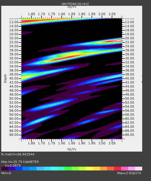
| Estimated Moho Depth: |
20.75 km |
| Estimated Crust Vp/Vs: |
2.10 |
| Assumed Crust Vp: |
6.444 km/s |
| Estimated Crust Vs: |
3.072 km/s |
| Estimated Crust Poisson's Ratio: |
0.35 |
|
| Radial Match: |
86.982544 % |
| Radial Bump: |
327 |
| Transverse Match: |
61.342087 % |
| Transverse Bump: |
400 |
| SOD ConfigId: |
1634031 |
| Insert Time: |
2016-07-25 02:12:52.784 +0000 |
| GWidth: |
2.5 |
| Max Bumps: |
400 |
| Tol: |
0.001 |
|

Signal To Noise
| Channel | StoN | STA | LTA |
| NM:PENM:00:HHZ:20160711T02:07:46.57501Z | 4.246012 | 1.1437957E-6 | 2.6938113E-7 |
| NM:PENM:00:HHN:20160711T02:07:46.57501Z | 3.8798926 | 1.633734E-6 | 4.210771E-7 |
| NM:PENM:00:HHE:20160711T02:07:46.57501Z | 1.4067187 | 5.2720725E-7 | 3.74778E-7 |
| Arrivals |
| Ps | 3.8 SECOND |
| PpPs | 9.4 SECOND |
| PsPs/PpSs | 13 SECOND |


