You are here: Home > Network List > NM - Cooperative New Madrid Seismic Network Stations List
> Station PEBM Pemiscot Bayou,MO > Earthquake Result Viewer
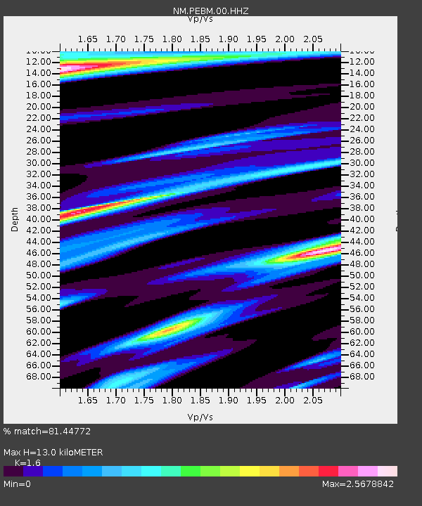
PEBM Pemiscot Bayou,MO - Earthquake Result Viewer
| Earthquake location: |
Near Coast Of Ecuador |
| Earthquake latitude/longitude: |
0.6/-79.6 |
| Earthquake time(UTC): |
2016/07/11 (193) 02:01:09 GMT |
| Earthquake Depth: |
14 km |
| Earthquake Magnitude: |
5.8 MWW, 5.7 MWB, 5.9 MWC |
| Earthquake Catalog/Contributor: |
NEIC PDE/NEIC COMCAT |
|
| Network: |
NM Cooperative New Madrid Seismic Network |
| Station: |
PEBM Pemiscot Bayou,MO |
| Lat/Lon: |
36.11 N/89.86 W |
| Elevation: |
76 m |
|
| Distance: |
36.6 deg |
| Az: |
346.066 deg |
| Baz: |
162.7 deg |
| Ray Param: |
0.07657547 |
| Estimated Moho Depth: |
13.0 km |
| Estimated Crust Vp/Vs: |
1.60 |
| Assumed Crust Vp: |
6.444 km/s |
| Estimated Crust Vs: |
4.027 km/s |
| Estimated Crust Poisson's Ratio: |
0.18 |
|
| Radial Match: |
81.44772 % |
| Radial Bump: |
324 |
| Transverse Match: |
66.345314 % |
| Transverse Bump: |
375 |
| SOD ConfigId: |
1634031 |
| Insert Time: |
2016-07-25 02:12:57.328 +0000 |
| GWidth: |
2.5 |
| Max Bumps: |
400 |
| Tol: |
0.001 |
|

Signal To Noise
| Channel | StoN | STA | LTA |
| NM:PEBM:00:HHZ:20160711T02:07:44.30499Z | 7.6304216 | 9.998549E-7 | 1.3103535E-7 |
| NM:PEBM:00:HHN:20160711T02:07:44.30499Z | 3.689307 | 9.357195E-7 | 2.5363016E-7 |
| NM:PEBM:00:HHE:20160711T02:07:44.30499Z | 2.1529553 | 5.860039E-7 | 2.7218584E-7 |
| Arrivals |
| Ps | 1.3 SECOND |
| PpPs | 4.8 SECOND |
| PsPs/PpSs | 6.1 SECOND |


