You are here: Home > Network List > TA - USArray Transportable Network (new EarthScope stations) Stations List
> Station O15A The Old Anderson's Place, Rush Valley, UT, USA > Earthquake Result Viewer
O15A The Old Anderson's Place, Rush Valley, UT, USA - Earthquake Result Viewer
| Earthquake location: |
Andreanof Islands, Aleutian Is. |
| Earthquake latitude/longitude: |
51.4/-179.5 |
| Earthquake time(UTC): |
2007/12/19 (353) 09:30:27 GMT |
| Earthquake Depth: |
29 km |
| Earthquake Magnitude: |
6.4 MB, 7.1 MS, 7.1 MW, 7.0 MW |
| Earthquake Catalog/Contributor: |
WHDF/NEIC |
|
| Network: |
TA USArray Transportable Network (new EarthScope stations) |
| Station: |
O15A The Old Anderson's Place, Rush Valley, UT, USA |
| Lat/Lon: |
40.28 N/112.47 W |
| Elevation: |
1611 m |
|
| Distance: |
46.5 deg |
| Az: |
76.327 deg |
| Baz: |
307.223 deg |
| Ray Param: |
0.07057129 |
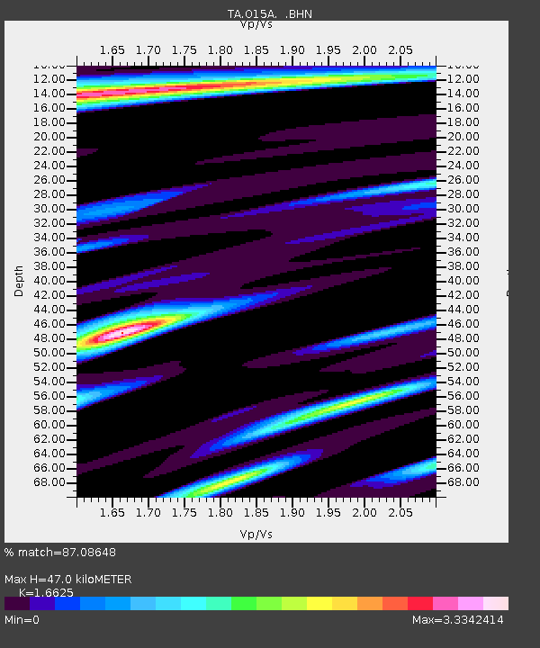
| Estimated Moho Depth: |
47.0 km |
| Estimated Crust Vp/Vs: |
1.66 |
| Assumed Crust Vp: |
6.276 km/s |
| Estimated Crust Vs: |
3.775 km/s |
| Estimated Crust Poisson's Ratio: |
0.22 |
|
| Radial Match: |
87.08648 % |
| Radial Bump: |
400 |
| Transverse Match: |
84.17771 % |
| Transverse Bump: |
400 |
| SOD ConfigId: |
2564 |
| Insert Time: |
2010-03-06 14:59:27.988 +0000 |
| GWidth: |
2.5 |
| Max Bumps: |
400 |
| Tol: |
0.001 |
|

Signal To Noise
| Channel | StoN | STA | LTA |
| TA:O15A: :BHN:20071219T09:38:20.925009Z | 3.4294138 | 1.8572673E-6 | 5.4156993E-7 |
| TA:O15A: :BHE:20071219T09:38:20.925009Z | 4.11817 | 1.7633141E-6 | 4.2817905E-7 |
| TA:O15A: :BHZ:20071219T09:38:20.925009Z | 17.084118 | 3.5033777E-6 | 2.0506636E-7 |
| Arrivals |
| Ps | 5.3 SECOND |
| PpPs | 19 SECOND |
| PsPs/PpSs | 24 SECOND |


