You are here: Home > Network List > TA - USArray Transportable Network (new EarthScope stations) Stations List
> Station F17K Baldwin Penninsula, AK, USA > Earthquake Result Viewer
F17K Baldwin Penninsula, AK, USA - Earthquake Result Viewer
| Earthquake location: |
Southeast Of Loyalty Islands |
| Earthquake latitude/longitude: |
-22.2/170.0 |
| Earthquake time(UTC): |
2018/08/29 (241) 03:51:55 GMT |
| Earthquake Depth: |
10 km |
| Earthquake Magnitude: |
7.0 Mi |
| Earthquake Catalog/Contributor: |
NEIC PDE/pt |
|
| Network: |
TA USArray Transportable Network (new EarthScope stations) |
| Station: |
F17K Baldwin Penninsula, AK, USA |
| Lat/Lon: |
66.44 N/161.25 W |
| Elevation: |
51 m |
|
| Distance: |
91.0 deg |
| Az: |
11.157 deg |
| Baz: |
206.499 deg |
| Ray Param: |
0.041633934 |
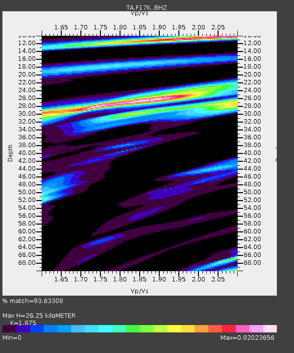
| Estimated Moho Depth: |
26.25 km |
| Estimated Crust Vp/Vs: |
1.88 |
| Assumed Crust Vp: |
6.276 km/s |
| Estimated Crust Vs: |
3.347 km/s |
| Estimated Crust Poisson's Ratio: |
0.30 |
|
| Radial Match: |
93.63308 % |
| Radial Bump: |
400 |
| Transverse Match: |
82.546555 % |
| Transverse Bump: |
400 |
| SOD ConfigId: |
13570011 |
| Insert Time: |
2019-05-01 01:13:47.781 +0000 |
| GWidth: |
2.5 |
| Max Bumps: |
400 |
| Tol: |
0.001 |
|

Signal To Noise
| Channel | StoN | STA | LTA |
| TA:F17K: :BHZ:20180829T04:04:26.500Z | 13.599589 | 1.1543405E-6 | 8.488054E-8 |
| TA:F17K: :BHN:20180829T04:04:26.500Z | 3.0945737 | 3.49989E-7 | 1.1309764E-7 |
| TA:F17K: :BHE:20180829T04:04:26.500Z | 2.0983565 | 2.022871E-7 | 9.640264E-8 |
| Arrivals |
| Ps | 3.7 SECOND |
| PpPs | 12 SECOND |
| PsPs/PpSs | 16 SECOND |


