You are here: Home > Network List > TA - USArray Transportable Network (new EarthScope stations) Stations List
> Station O15A The Old Anderson's Place, Rush Valley, UT, USA > Earthquake Result Viewer
O15A The Old Anderson's Place, Rush Valley, UT, USA - Earthquake Result Viewer
| Earthquake location: |
Northern Chile |
| Earthquake latitude/longitude: |
-22.2/-69.9 |
| Earthquake time(UTC): |
2007/11/14 (318) 15:40:50 GMT |
| Earthquake Depth: |
40 km |
| Earthquake Magnitude: |
6.7 MB, 7.4 MS, 7.7 MW, 7.4 ME |
| Earthquake Catalog/Contributor: |
WHDF/NEIC |
|
| Network: |
TA USArray Transportable Network (new EarthScope stations) |
| Station: |
O15A The Old Anderson's Place, Rush Valley, UT, USA |
| Lat/Lon: |
40.28 N/112.47 W |
| Elevation: |
1611 m |
|
| Distance: |
73.8 deg |
| Az: |
327.377 deg |
| Baz: |
139.243 deg |
| Ray Param: |
0.052714173 |
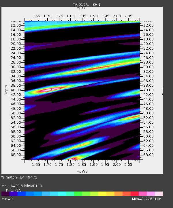
| Estimated Moho Depth: |
39.5 km |
| Estimated Crust Vp/Vs: |
1.72 |
| Assumed Crust Vp: |
6.276 km/s |
| Estimated Crust Vs: |
3.659 km/s |
| Estimated Crust Poisson's Ratio: |
0.24 |
|
| Radial Match: |
84.49475 % |
| Radial Bump: |
400 |
| Transverse Match: |
78.983376 % |
| Transverse Bump: |
400 |
| SOD ConfigId: |
2564 |
| Insert Time: |
2010-03-06 14:59:31.099 +0000 |
| GWidth: |
2.5 |
| Max Bumps: |
400 |
| Tol: |
0.001 |
|

Signal To Noise
| Channel | StoN | STA | LTA |
| TA:O15A: :BHN:20071114T15:51:49.699006Z | 3.9807615 | 1.2743337E-6 | 3.201231E-7 |
| TA:O15A: :BHE:20071114T15:51:49.699006Z | 6.434854 | 1.9527738E-6 | 3.0346823E-7 |
| TA:O15A: :BHZ:20071114T15:51:49.699006Z | 22.60991 | 4.969082E-6 | 2.1977453E-7 |
| Arrivals |
| Ps | 4.7 SECOND |
| PpPs | 17 SECOND |
| PsPs/PpSs | 21 SECOND |


