You are here: Home > Network List > NM - Cooperative New Madrid Seismic Network Stations List
> Station UTMT Martin, TN > Earthquake Result Viewer
UTMT Martin, TN - Earthquake Result Viewer
| Earthquake location: |
Near Coast Of Ecuador |
| Earthquake latitude/longitude: |
0.6/-79.6 |
| Earthquake time(UTC): |
2016/07/11 (193) 02:01:09 GMT |
| Earthquake Depth: |
14 km |
| Earthquake Magnitude: |
5.8 MWW, 5.7 MWB, 5.9 MWC |
| Earthquake Catalog/Contributor: |
NEIC PDE/NEIC COMCAT |
|
| Network: |
NM Cooperative New Madrid Seismic Network |
| Station: |
UTMT Martin, TN |
| Lat/Lon: |
36.35 N/88.86 W |
| Elevation: |
110 m |
|
| Distance: |
36.6 deg |
| Az: |
347.476 deg |
| Baz: |
164.419 deg |
| Ray Param: |
0.07657651 |
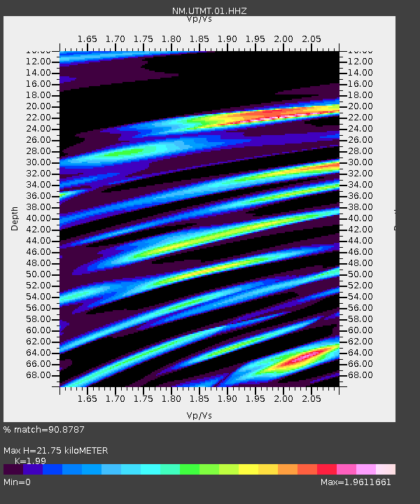
| Estimated Moho Depth: |
21.75 km |
| Estimated Crust Vp/Vs: |
1.99 |
| Assumed Crust Vp: |
6.444 km/s |
| Estimated Crust Vs: |
3.238 km/s |
| Estimated Crust Poisson's Ratio: |
0.33 |
|
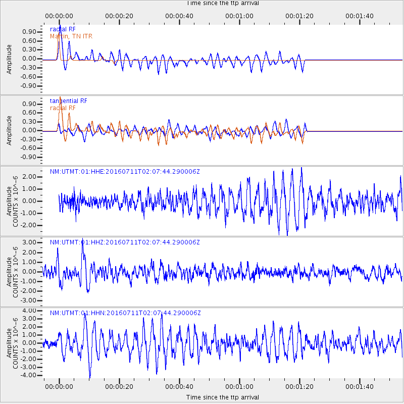
| Radial Match: |
90.8787 % |
| Radial Bump: |
353 |
| Transverse Match: |
71.74496 % |
| Transverse Bump: |
400 |
| SOD ConfigId: |
1634031 |
| Insert Time: |
2016-07-25 02:13:08.565 +0000 |
| GWidth: |
2.5 |
| Max Bumps: |
400 |
| Tol: |
0.001 |
|
Signal To Noise
| Channel | StoN | STA | LTA |
| NM:UTMT:01:HHZ:20160711T02:07:44.290006Z | 2.8796499 | 9.708965E-7 | 3.3715784E-7 |
| NM:UTMT:01:HHN:20160711T02:07:44.290006Z | 2.5716982 | 1.0684402E-6 | 4.1546096E-7 |
| NM:UTMT:01:HHE:20160711T02:07:44.290006Z | 1.3163209 | 4.922736E-7 | 3.7397692E-7 |
| Arrivals |
| Ps | 3.6 SECOND |
| PpPs | 9.4 SECOND |
| PsPs/PpSs | 13 SECOND |


