You are here: Home > Network List > TA - USArray Transportable Network (new EarthScope stations) Stations List
> Station O15A The Old Anderson's Place, Rush Valley, UT, USA > Earthquake Result Viewer
O15A The Old Anderson's Place, Rush Valley, UT, USA - Earthquake Result Viewer
| Earthquake location: |
Central Mid-Atlantic Ridge |
| Earthquake latitude/longitude: |
0.7/-30.3 |
| Earthquake time(UTC): |
2007/07/03 (184) 08:26:00 GMT |
| Earthquake Depth: |
10 km |
| Earthquake Magnitude: |
5.8 MB, 5.9 MS, 6.3 MW, 6.1 MW |
| Earthquake Catalog/Contributor: |
WHDF/NEIC |
|
| Network: |
TA USArray Transportable Network (new EarthScope stations) |
| Station: |
O15A The Old Anderson's Place, Rush Valley, UT, USA |
| Lat/Lon: |
40.28 N/112.47 W |
| Elevation: |
1611 m |
|
| Distance: |
83.6 deg |
| Az: |
310.295 deg |
| Baz: |
94.498 deg |
| Ray Param: |
0.04608793 |
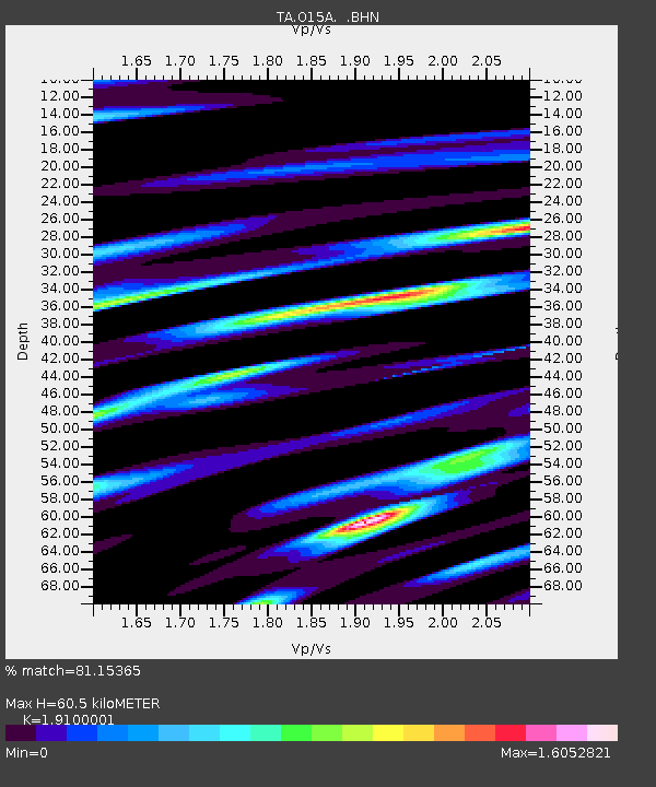
| Estimated Moho Depth: |
60.5 km |
| Estimated Crust Vp/Vs: |
1.91 |
| Assumed Crust Vp: |
6.276 km/s |
| Estimated Crust Vs: |
3.286 km/s |
| Estimated Crust Poisson's Ratio: |
0.31 |
|
| Radial Match: |
81.15365 % |
| Radial Bump: |
347 |
| Transverse Match: |
77.78947 % |
| Transverse Bump: |
400 |
| SOD ConfigId: |
2564 |
| Insert Time: |
2010-03-06 14:59:40.663 +0000 |
| GWidth: |
2.5 |
| Max Bumps: |
400 |
| Tol: |
0.001 |
|

Signal To Noise
| Channel | StoN | STA | LTA |
| TA:O15A: :BHN:20070703T08:37:57.625002Z | 1.7345656 | 3.814487E-7 | 2.199102E-7 |
| TA:O15A: :BHE:20070703T08:37:57.625002Z | 1.8623801 | 4.5496844E-7 | 2.4429409E-7 |
| TA:O15A: :BHZ:20070703T08:37:57.625002Z | 2.196733 | 3.978037E-7 | 1.8108878E-7 |
| Arrivals |
| Ps | 9.0 SECOND |
| PpPs | 27 SECOND |
| PsPs/PpSs | 36 SECOND |


