You are here: Home > Network List > TA - USArray Transportable Network (new EarthScope stations) Stations List
> Station O15A The Old Anderson's Place, Rush Valley, UT, USA > Earthquake Result Viewer
O15A The Old Anderson's Place, Rush Valley, UT, USA - Earthquake Result Viewer
| Earthquake location: |
Central Mid-Atlantic Ridge |
| Earthquake latitude/longitude: |
7.3/-34.9 |
| Earthquake time(UTC): |
2008/05/23 (144) 19:35:34 GMT |
| Earthquake Depth: |
9.0 km |
| Earthquake Magnitude: |
6.0 MB, 6.4 MS, 6.5 MW, 6.5 MW |
| Earthquake Catalog/Contributor: |
WHDF/NEIC |
|
| Network: |
TA USArray Transportable Network (new EarthScope stations) |
| Station: |
O15A The Old Anderson's Place, Rush Valley, UT, USA |
| Lat/Lon: |
40.28 N/112.47 W |
| Elevation: |
1611 m |
|
| Distance: |
75.8 deg |
| Az: |
309.598 deg |
| Baz: |
92.408 deg |
| Ray Param: |
0.05140414 |
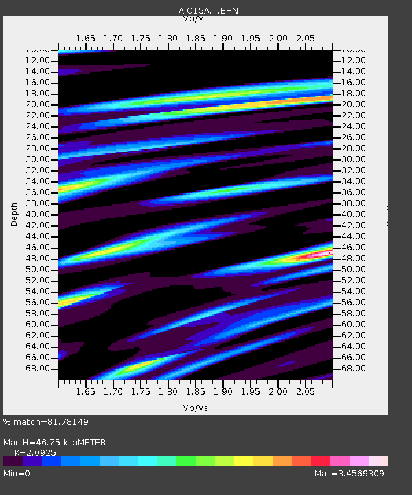
| Estimated Moho Depth: |
46.75 km |
| Estimated Crust Vp/Vs: |
2.09 |
| Assumed Crust Vp: |
6.276 km/s |
| Estimated Crust Vs: |
2.999 km/s |
| Estimated Crust Poisson's Ratio: |
0.35 |
|
| Radial Match: |
81.78149 % |
| Radial Bump: |
358 |
| Transverse Match: |
75.26485 % |
| Transverse Bump: |
400 |
| SOD ConfigId: |
2504 |
| Insert Time: |
2010-03-06 14:59:42.375 +0000 |
| GWidth: |
2.5 |
| Max Bumps: |
400 |
| Tol: |
0.001 |
|

Signal To Noise
| Channel | StoN | STA | LTA |
| TA:O15A: :BHN:20080523T19:46:50.025022Z | 2.1141152 | 6.224773E-7 | 2.9443868E-7 |
| TA:O15A: :BHE:20080523T19:46:50.025022Z | 0.93084884 | 9.387523E-7 | 1.0084906E-6 |
| TA:O15A: :BHZ:20080523T19:46:50.025022Z | 1.266658 | 6.9724535E-7 | 5.5046064E-7 |
| Arrivals |
| Ps | 8.4 SECOND |
| PpPs | 22 SECOND |
| PsPs/PpSs | 31 SECOND |


