You are here: Home > Network List > TA - USArray Transportable Network (new EarthScope stations) Stations List
> Station J25K Salcha River, AK, USA > Earthquake Result Viewer
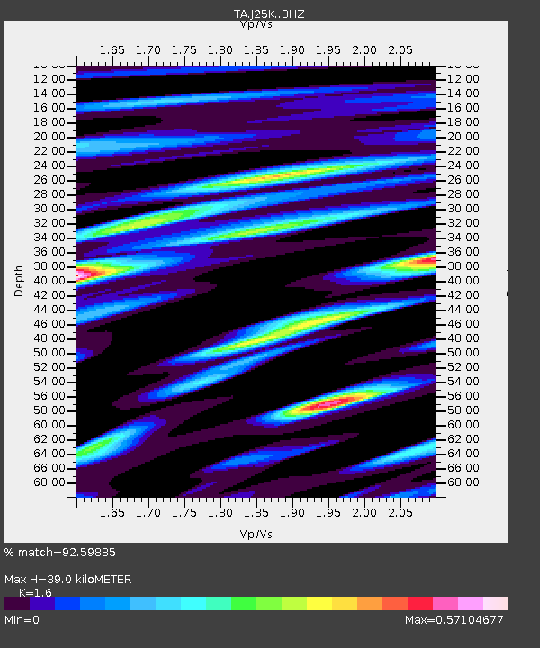
J25K Salcha River, AK, USA - Earthquake Result Viewer
| Earthquake location: |
Southeast Of Loyalty Islands |
| Earthquake latitude/longitude: |
-22.2/170.0 |
| Earthquake time(UTC): |
2018/08/29 (241) 03:51:55 GMT |
| Earthquake Depth: |
10 km |
| Earthquake Magnitude: |
7.0 Mi |
| Earthquake Catalog/Contributor: |
NEIC PDE/pt |
|
| Network: |
TA USArray Transportable Network (new EarthScope stations) |
| Station: |
J25K Salcha River, AK, USA |
| Lat/Lon: |
64.61 N/145.37 W |
| Elevation: |
949 m |
|
| Distance: |
93.1 deg |
| Az: |
17.663 deg |
| Baz: |
220.72 deg |
| Ray Param: |
0.04132177 |
| Estimated Moho Depth: |
39.0 km |
| Estimated Crust Vp/Vs: |
1.60 |
| Assumed Crust Vp: |
6.566 km/s |
| Estimated Crust Vs: |
4.104 km/s |
| Estimated Crust Poisson's Ratio: |
0.18 |
|
| Radial Match: |
92.59885 % |
| Radial Bump: |
400 |
| Transverse Match: |
78.282265 % |
| Transverse Bump: |
400 |
| SOD ConfigId: |
13570011 |
| Insert Time: |
2019-05-01 01:14:29.442 +0000 |
| GWidth: |
2.5 |
| Max Bumps: |
400 |
| Tol: |
0.001 |
|

Signal To Noise
| Channel | StoN | STA | LTA |
| TA:J25K: :BHZ:20180829T04:04:36.349976Z | 7.838003 | 7.914185E-7 | 1.0097195E-7 |
| TA:J25K: :BHN:20180829T04:04:36.349976Z | 3.0020158 | 2.3405143E-7 | 7.7964756E-8 |
| TA:J25K: :BHE:20180829T04:04:36.349976Z | 3.216163 | 2.071763E-7 | 6.441723E-8 |
| Arrivals |
| Ps | 3.6 SECOND |
| PpPs | 15 SECOND |
| PsPs/PpSs | 19 SECOND |


