You are here: Home > Network List > TA - USArray Transportable Network (new EarthScope stations) Stations List
> Station M31M Drury Creek, Yukon, CA > Earthquake Result Viewer
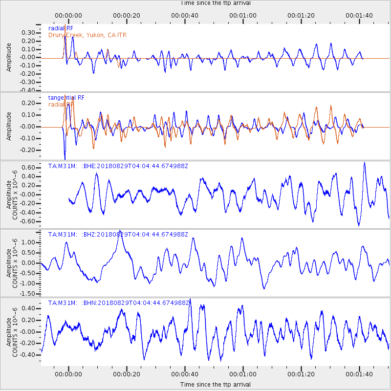
M31M Drury Creek, Yukon, CA - Earthquake Result Viewer
*The percent match for this event was below the threshold and hence no stack was calculated.
| Earthquake location: |
Southeast Of Loyalty Islands |
| Earthquake latitude/longitude: |
-22.2/170.0 |
| Earthquake time(UTC): |
2018/08/29 (241) 03:51:55 GMT |
| Earthquake Depth: |
10 km |
| Earthquake Magnitude: |
7.0 Mi |
| Earthquake Catalog/Contributor: |
NEIC PDE/pt |
|
| Network: |
TA USArray Transportable Network (new EarthScope stations) |
| Station: |
M31M Drury Creek, Yukon, CA |
| Lat/Lon: |
62.20 N/134.39 W |
| Elevation: |
639 m |
|
| Distance: |
95.0 deg |
| Az: |
22.856 deg |
| Baz: |
230.166 deg |
| Ray Param: |
$rayparam |
*The percent match for this event was below the threshold and hence was not used in the summary stack. |
|
| Radial Match: |
76.79356 % |
| Radial Bump: |
400 |
| Transverse Match: |
54.98037 % |
| Transverse Bump: |
400 |
| SOD ConfigId: |
13570011 |
| Insert Time: |
2019-05-01 01:14:58.048 +0000 |
| GWidth: |
2.5 |
| Max Bumps: |
400 |
| Tol: |
0.001 |
|
Signal To Noise
| Channel | StoN | STA | LTA |
| TA:M31M: :BHZ:20180829T04:04:44.674988Z | 2.7948005 | 5.2494875E-7 | 1.878305E-7 |
| TA:M31M: :BHN:20180829T04:04:44.674988Z | 0.38126212 | 9.8513745E-8 | 2.583885E-7 |
| TA:M31M: :BHE:20180829T04:04:44.674988Z | 0.5504128 | 1.0611764E-7 | 1.9279646E-7 |
| Arrivals |
| Ps | |
| PpPs | |
| PsPs/PpSs | |


