You are here: Home > Network List > TA - USArray Transportable Network (new EarthScope stations) Stations List
> Station O15K Ungalikthiuk River, AK, USA > Earthquake Result Viewer
O15K Ungalikthiuk River, AK, USA - Earthquake Result Viewer
| Earthquake location: |
Southeast Of Loyalty Islands |
| Earthquake latitude/longitude: |
-22.2/170.0 |
| Earthquake time(UTC): |
2018/08/29 (241) 03:51:55 GMT |
| Earthquake Depth: |
10 km |
| Earthquake Magnitude: |
7.0 Mi |
| Earthquake Catalog/Contributor: |
NEIC PDE/pt |
|
| Network: |
TA USArray Transportable Network (new EarthScope stations) |
| Station: |
O15K Ungalikthiuk River, AK, USA |
| Lat/Lon: |
59.18 N/159.82 W |
| Elevation: |
306 m |
|
| Distance: |
84.8 deg |
| Az: |
15.075 deg |
| Baz: |
207.912 deg |
| Ray Param: |
0.045221567 |
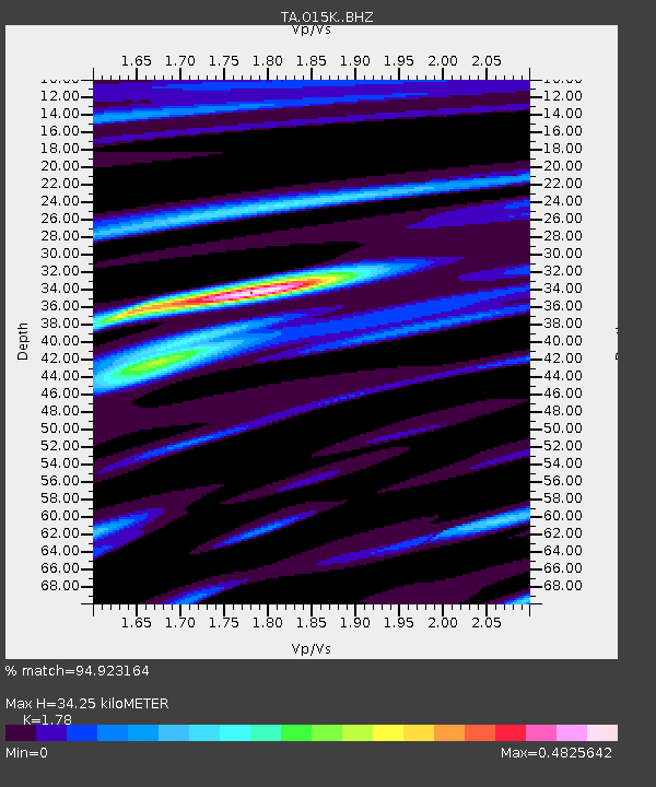
| Estimated Moho Depth: |
34.25 km |
| Estimated Crust Vp/Vs: |
1.78 |
| Assumed Crust Vp: |
6.24 km/s |
| Estimated Crust Vs: |
3.506 km/s |
| Estimated Crust Poisson's Ratio: |
0.27 |
|
| Radial Match: |
94.923164 % |
| Radial Bump: |
386 |
| Transverse Match: |
84.234344 % |
| Transverse Bump: |
400 |
| SOD ConfigId: |
13570011 |
| Insert Time: |
2019-05-01 01:15:08.552 +0000 |
| GWidth: |
2.5 |
| Max Bumps: |
400 |
| Tol: |
0.001 |
|

Signal To Noise
| Channel | StoN | STA | LTA |
| TA:O15K: :BHZ:20180829T04:03:56.849976Z | 26.606165 | 2.0421778E-6 | 7.675582E-8 |
| TA:O15K: :BHN:20180829T04:03:56.849976Z | 6.3748684 | 5.618927E-7 | 8.814185E-8 |
| TA:O15K: :BHE:20180829T04:03:56.849976Z | 8.46673 | 3.9081507E-7 | 4.6158917E-8 |
| Arrivals |
| Ps | 4.4 SECOND |
| PpPs | 15 SECOND |
| PsPs/PpSs | 19 SECOND |


