You are here: Home > Network List > TA - USArray Transportable Network (new EarthScope stations) Stations List
> Station O19K Port Alsworth, AK, USA > Earthquake Result Viewer
O19K Port Alsworth, AK, USA - Earthquake Result Viewer
| Earthquake location: |
Southeast Of Loyalty Islands |
| Earthquake latitude/longitude: |
-22.2/170.0 |
| Earthquake time(UTC): |
2018/08/29 (241) 03:51:55 GMT |
| Earthquake Depth: |
10 km |
| Earthquake Magnitude: |
7.0 Mi |
| Earthquake Catalog/Contributor: |
NEIC PDE/pt |
|
| Network: |
TA USArray Transportable Network (new EarthScope stations) |
| Station: |
O19K Port Alsworth, AK, USA |
| Lat/Lon: |
60.20 N/154.32 W |
| Elevation: |
96 m |
|
| Distance: |
87.1 deg |
| Az: |
16.972 deg |
| Baz: |
212.791 deg |
| Ray Param: |
0.04357277 |
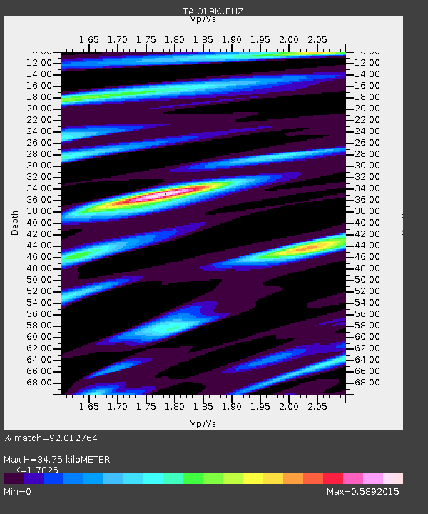
| Estimated Moho Depth: |
34.75 km |
| Estimated Crust Vp/Vs: |
1.78 |
| Assumed Crust Vp: |
6.566 km/s |
| Estimated Crust Vs: |
3.684 km/s |
| Estimated Crust Poisson's Ratio: |
0.27 |
|
| Radial Match: |
92.012764 % |
| Radial Bump: |
400 |
| Transverse Match: |
85.46411 % |
| Transverse Bump: |
400 |
| SOD ConfigId: |
13570011 |
| Insert Time: |
2019-05-01 01:15:11.470 +0000 |
| GWidth: |
2.5 |
| Max Bumps: |
400 |
| Tol: |
0.001 |
|

Signal To Noise
| Channel | StoN | STA | LTA |
| TA:O19K: :BHZ:20180829T04:04:08.174988Z | 11.295468 | 1.5681917E-6 | 1.388337E-7 |
| TA:O19K: :BHN:20180829T04:04:08.174988Z | 4.3514752 | 5.085958E-7 | 1.1687893E-7 |
| TA:O19K: :BHE:20180829T04:04:08.174988Z | 2.8449063 | 2.9533217E-7 | 1.0381086E-7 |
| Arrivals |
| Ps | 4.2 SECOND |
| PpPs | 14 SECOND |
| PsPs/PpSs | 19 SECOND |


