You are here: Home > Network List > TA - USArray Transportable Network (new EarthScope stations) Stations List
> Station Q20K Shuyak Island, AK, USA > Earthquake Result Viewer
Q20K Shuyak Island, AK, USA - Earthquake Result Viewer
| Earthquake location: |
Southeast Of Loyalty Islands |
| Earthquake latitude/longitude: |
-22.2/170.0 |
| Earthquake time(UTC): |
2018/08/29 (241) 03:51:55 GMT |
| Earthquake Depth: |
10 km |
| Earthquake Magnitude: |
7.0 Mi |
| Earthquake Catalog/Contributor: |
NEIC PDE/pt |
|
| Network: |
TA USArray Transportable Network (new EarthScope stations) |
| Station: |
Q20K Shuyak Island, AK, USA |
| Lat/Lon: |
58.61 N/152.39 W |
| Elevation: |
180 m |
|
| Distance: |
86.3 deg |
| Az: |
18.677 deg |
| Baz: |
214.544 deg |
| Ray Param: |
0.04413863 |
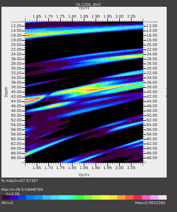
| Estimated Moho Depth: |
36.5 km |
| Estimated Crust Vp/Vs: |
2.06 |
| Assumed Crust Vp: |
5.989 km/s |
| Estimated Crust Vs: |
2.907 km/s |
| Estimated Crust Poisson's Ratio: |
0.35 |
|
| Radial Match: |
87.57357 % |
| Radial Bump: |
400 |
| Transverse Match: |
76.90099 % |
| Transverse Bump: |
400 |
| SOD ConfigId: |
13570011 |
| Insert Time: |
2019-05-01 01:15:25.525 +0000 |
| GWidth: |
2.5 |
| Max Bumps: |
400 |
| Tol: |
0.001 |
|

Signal To Noise
| Channel | StoN | STA | LTA |
| TA:Q20K: :BHZ:20180829T04:04:04.375Z | 6.3138595 | 2.2490105E-6 | 3.562022E-7 |
| TA:Q20K: :BHN:20180829T04:04:04.375Z | 2.8948703 | 1.0006179E-6 | 3.4565204E-7 |
| TA:Q20K: :BHE:20180829T04:04:04.375Z | 2.556985 | 7.824477E-7 | 3.0600407E-7 |
| Arrivals |
| Ps | 6.6 SECOND |
| PpPs | 18 SECOND |
| PsPs/PpSs | 25 SECOND |


