You are here: Home > Network List > UM - University of Montana - Missoula Stations List
> Station NVMT Nevada Creek > Earthquake Result Viewer
NVMT Nevada Creek - Earthquake Result Viewer
| Earthquake location: |
Southeast Of Loyalty Islands |
| Earthquake latitude/longitude: |
-22.2/170.0 |
| Earthquake time(UTC): |
2018/08/29 (241) 03:51:55 GMT |
| Earthquake Depth: |
10 km |
| Earthquake Magnitude: |
7.0 Mi |
| Earthquake Catalog/Contributor: |
NEIC PDE/pt |
|
| Network: |
UM University of Montana - Missoula |
| Station: |
NVMT Nevada Creek |
| Lat/Lon: |
46.79 N/112.60 W |
| Elevation: |
1741 m |
|
| Distance: |
97.7 deg |
| Az: |
42.592 deg |
| Baz: |
245.9 deg |
| Ray Param: |
0.04013273 |
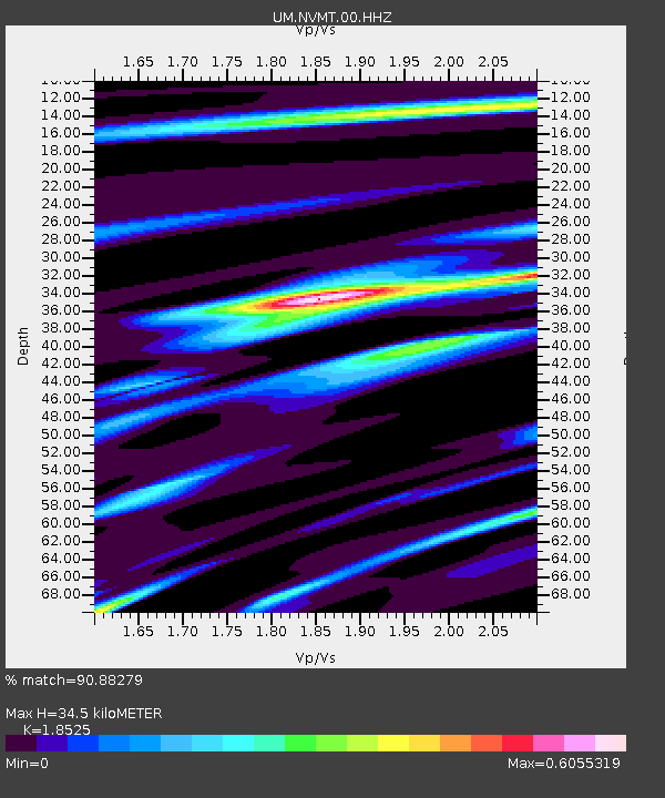
| Estimated Moho Depth: |
34.5 km |
| Estimated Crust Vp/Vs: |
1.85 |
| Assumed Crust Vp: |
6.353 km/s |
| Estimated Crust Vs: |
3.429 km/s |
| Estimated Crust Poisson's Ratio: |
0.29 |
|
| Radial Match: |
90.88279 % |
| Radial Bump: |
353 |
| Transverse Match: |
67.46676 % |
| Transverse Bump: |
400 |
| SOD ConfigId: |
13570011 |
| Insert Time: |
2019-05-01 01:15:57.081 +0000 |
| GWidth: |
2.5 |
| Max Bumps: |
400 |
| Tol: |
0.001 |
|

Signal To Noise
| Channel | StoN | STA | LTA |
| UM:NVMT:00:HHZ:20180829T04:04:57.070007Z | 6.2876635 | 5.56187E-7 | 8.8456865E-8 |
| UM:NVMT:00:HHN:20180829T04:04:57.070007Z | 1.0591322 | 7.606621E-8 | 7.181938E-8 |
| UM:NVMT:00:HHE:20180829T04:04:57.070007Z | 2.3103027 | 1.9498142E-7 | 8.439648E-8 |
| Arrivals |
| Ps | 4.7 SECOND |
| PpPs | 15 SECOND |
| PsPs/PpSs | 20 SECOND |


