You are here: Home > Network List > US - United States National Seismic Network Stations List
> Station AMTX Amarillo, Texas, USA > Earthquake Result Viewer
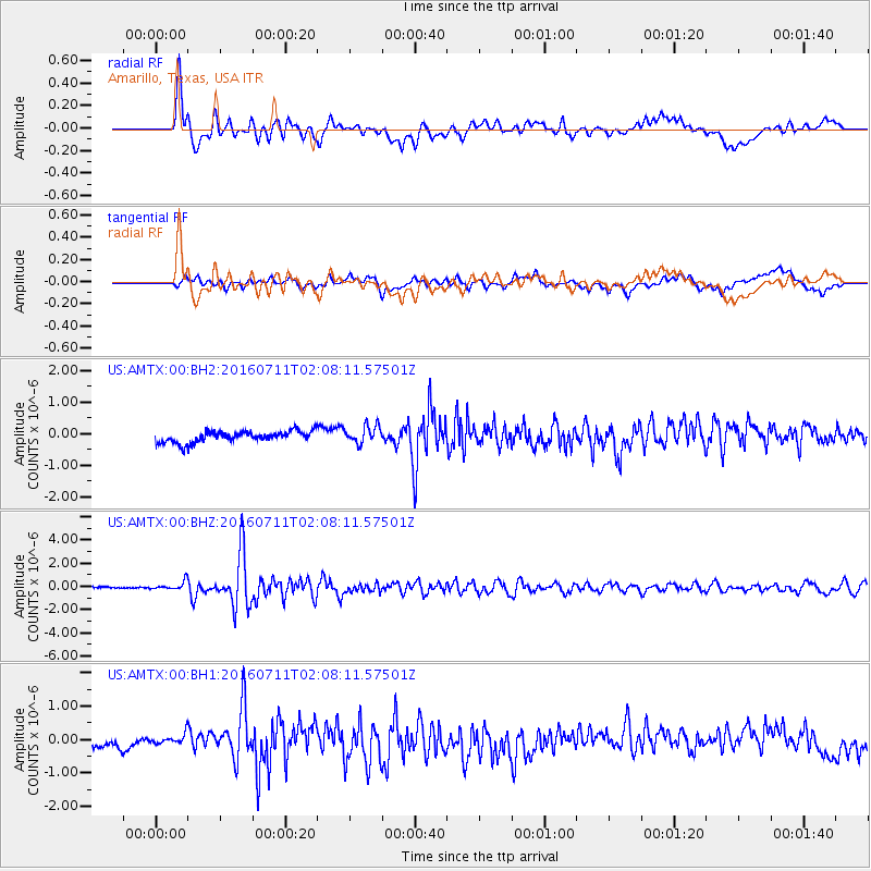
AMTX Amarillo, Texas, USA - Earthquake Result Viewer
*The percent match for this event was below the threshold and hence no stack was calculated.
| Earthquake location: |
Near Coast Of Ecuador |
| Earthquake latitude/longitude: |
0.6/-79.6 |
| Earthquake time(UTC): |
2016/07/11 (193) 02:01:09 GMT |
| Earthquake Depth: |
14 km |
| Earthquake Magnitude: |
5.8 MWW, 5.7 MWB, 5.9 MWC |
| Earthquake Catalog/Contributor: |
NEIC PDE/NEIC COMCAT |
|
| Network: |
US United States National Seismic Network |
| Station: |
AMTX Amarillo, Texas, USA |
| Lat/Lon: |
34.53 N/101.41 W |
| Elevation: |
1010 m |
|
| Distance: |
39.4 deg |
| Az: |
331.192 deg |
| Baz: |
144.293 deg |
| Ray Param: |
$rayparam |
*The percent match for this event was below the threshold and hence was not used in the summary stack. |
|
| Radial Match: |
76.37006 % |
| Radial Bump: |
400 |
| Transverse Match: |
56.999733 % |
| Transverse Bump: |
400 |
| SOD ConfigId: |
1634031 |
| Insert Time: |
2016-07-25 02:14:35.542 +0000 |
| GWidth: |
2.5 |
| Max Bumps: |
400 |
| Tol: |
0.001 |
|
Signal To Noise
| Channel | StoN | STA | LTA |
| US:AMTX:00:BHZ:20160711T02:08:11.57501Z | 4.098603 | 3.6361473E-7 | 8.871675E-8 |
| US:AMTX:00:BH1:20160711T02:08:11.57501Z | 1.2695181 | 1.4798184E-7 | 1.1656536E-7 |
| US:AMTX:00:BH2:20160711T02:08:11.57501Z | 1.6241704 | 2.696351E-7 | 1.6601405E-7 |
| Arrivals |
| Ps | |
| PpPs | |
| PsPs/PpSs | |


