You are here: Home > Network List > UW - Pacific Northwest Regional Seismic Network Stations List
> Station LCCR Mulino, OR, USA > Earthquake Result Viewer
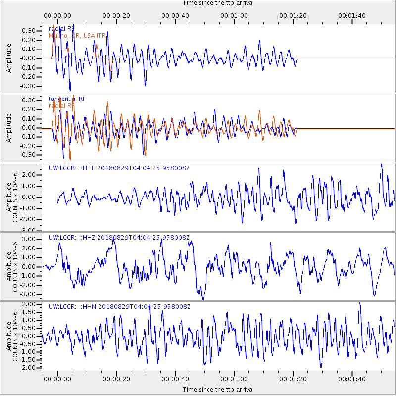
LCCR Mulino, OR, USA - Earthquake Result Viewer
*The percent match for this event was below the threshold and hence no stack was calculated.
| Earthquake location: |
Southeast Of Loyalty Islands |
| Earthquake latitude/longitude: |
-22.2/170.0 |
| Earthquake time(UTC): |
2018/08/29 (241) 03:51:55 GMT |
| Earthquake Depth: |
10 km |
| Earthquake Magnitude: |
7.0 Mi |
| Earthquake Catalog/Contributor: |
NEIC PDE/pt |
|
| Network: |
UW Pacific Northwest Regional Seismic Network |
| Station: |
LCCR Mulino, OR, USA |
| Lat/Lon: |
45.21 N/122.48 W |
| Elevation: |
273 m |
|
| Distance: |
90.9 deg |
| Az: |
40.8 deg |
| Baz: |
238.943 deg |
| Ray Param: |
$rayparam |
*The percent match for this event was below the threshold and hence was not used in the summary stack. |
|
| Radial Match: |
79.373886 % |
| Radial Bump: |
400 |
| Transverse Match: |
63.97649 % |
| Transverse Bump: |
400 |
| SOD ConfigId: |
13570011 |
| Insert Time: |
2019-05-01 01:16:34.684 +0000 |
| GWidth: |
2.5 |
| Max Bumps: |
400 |
| Tol: |
0.001 |
|
Signal To Noise
| Channel | StoN | STA | LTA |
| UW:LCCR: :HHZ:20180829T04:04:25.958008Z | 7.0950055 | 1.2455317E-6 | 1.755505E-7 |
| UW:LCCR: :HHN:20180829T04:04:25.958008Z | 0.9682684 | 3.6122344E-7 | 3.7306125E-7 |
| UW:LCCR: :HHE:20180829T04:04:25.958008Z | 1.4289875 | 5.007811E-7 | 3.5044468E-7 |
| Arrivals |
| Ps | |
| PpPs | |
| PsPs/PpSs | |


