You are here: Home > Network List > TA - USArray Transportable Network (new EarthScope stations) Stations List
> Station H16K Elim, AK, USA > Earthquake Result Viewer
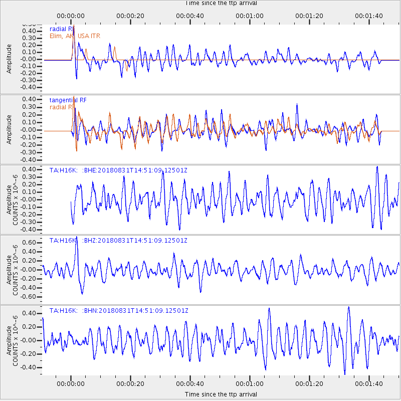
H16K Elim, AK, USA - Earthquake Result Viewer
*The percent match for this event was below the threshold and hence no stack was calculated.
| Earthquake location: |
Mindoro, Philippines |
| Earthquake latitude/longitude: |
13.6/120.9 |
| Earthquake time(UTC): |
2018/08/31 (243) 14:40:29 GMT |
| Earthquake Depth: |
140 km |
| Earthquake Magnitude: |
5.5 Mww |
| Earthquake Catalog/Contributor: |
NEIC PDE/us |
|
| Network: |
TA USArray Transportable Network (new EarthScope stations) |
| Station: |
H16K Elim, AK, USA |
| Lat/Lon: |
64.64 N/162.24 W |
| Elevation: |
216 m |
|
| Distance: |
72.2 deg |
| Az: |
26.133 deg |
| Baz: |
264.018 deg |
| Ray Param: |
$rayparam |
*The percent match for this event was below the threshold and hence was not used in the summary stack. |
|
| Radial Match: |
56.816032 % |
| Radial Bump: |
400 |
| Transverse Match: |
59.713966 % |
| Transverse Bump: |
400 |
| SOD ConfigId: |
13570011 |
| Insert Time: |
2019-05-01 01:27:50.536 +0000 |
| GWidth: |
2.5 |
| Max Bumps: |
400 |
| Tol: |
0.001 |
|
Signal To Noise
| Channel | StoN | STA | LTA |
| TA:H16K: :BHZ:20180831T14:51:09.12501Z | 3.1936753 | 3.3828687E-7 | 1.05924E-7 |
| TA:H16K: :BHN:20180831T14:51:09.12501Z | 0.45164505 | 5.8926865E-8 | 1.3047163E-7 |
| TA:H16K: :BHE:20180831T14:51:09.12501Z | 1.4246839 | 1.9287059E-7 | 1.3537782E-7 |
| Arrivals |
| Ps | |
| PpPs | |
| PsPs/PpSs | |


