You are here: Home > Network List > TA - USArray Transportable Network (new EarthScope stations) Stations List
> Station I23K Minto, Yukon-Koyukuk, AK, USA > Earthquake Result Viewer
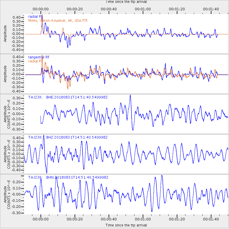
I23K Minto, Yukon-Koyukuk, AK, USA - Earthquake Result Viewer
*The percent match for this event was below the threshold and hence no stack was calculated.
| Earthquake location: |
Mindoro, Philippines |
| Earthquake latitude/longitude: |
13.6/120.9 |
| Earthquake time(UTC): |
2018/08/31 (243) 14:40:29 GMT |
| Earthquake Depth: |
140 km |
| Earthquake Magnitude: |
5.5 Mww |
| Earthquake Catalog/Contributor: |
NEIC PDE/us |
|
| Network: |
TA USArray Transportable Network (new EarthScope stations) |
| Station: |
I23K Minto, Yukon-Koyukuk, AK, USA |
| Lat/Lon: |
65.15 N/149.36 W |
| Elevation: |
149 m |
|
| Distance: |
77.7 deg |
| Az: |
25.628 deg |
| Baz: |
275.544 deg |
| Ray Param: |
$rayparam |
*The percent match for this event was below the threshold and hence was not used in the summary stack. |
|
| Radial Match: |
48.795044 % |
| Radial Bump: |
400 |
| Transverse Match: |
46.246906 % |
| Transverse Bump: |
400 |
| SOD ConfigId: |
13570011 |
| Insert Time: |
2019-05-01 01:27:57.337 +0000 |
| GWidth: |
2.5 |
| Max Bumps: |
400 |
| Tol: |
0.001 |
|
Signal To Noise
| Channel | StoN | STA | LTA |
| TA:I23K: :BHZ:20180831T14:51:40.549998Z | 2.4338467 | 2.531047E-7 | 1.0399369E-7 |
| TA:I23K: :BHN:20180831T14:51:40.549998Z | 1.1690394 | 1.2469543E-7 | 1.06664864E-7 |
| TA:I23K: :BHE:20180831T14:51:40.549998Z | 1.2125888 | 9.918143E-8 | 8.1793125E-8 |
| Arrivals |
| Ps | |
| PpPs | |
| PsPs/PpSs | |


