You are here: Home > Network List > TJ - Tajikistan National Seismic Network Stations List
> Station GARM Garm, Tajikistan > Earthquake Result Viewer
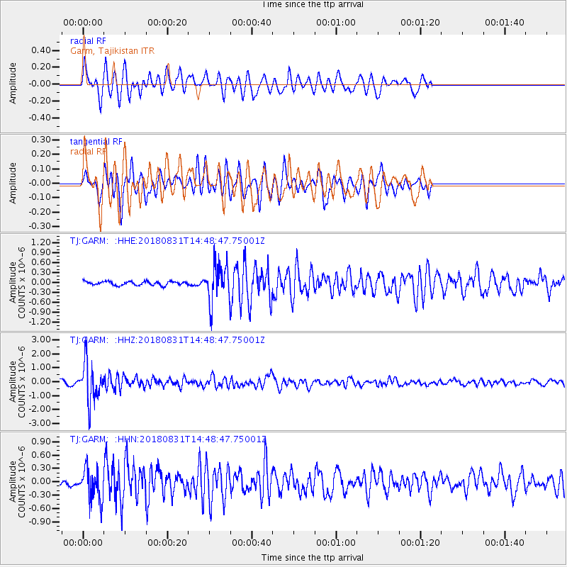
GARM Garm, Tajikistan - Earthquake Result Viewer
*The percent match for this event was below the threshold and hence no stack was calculated.
| Earthquake location: |
Mindoro, Philippines |
| Earthquake latitude/longitude: |
13.6/120.9 |
| Earthquake time(UTC): |
2018/08/31 (243) 14:40:29 GMT |
| Earthquake Depth: |
140 km |
| Earthquake Magnitude: |
5.5 Mww |
| Earthquake Catalog/Contributor: |
NEIC PDE/us |
|
| Network: |
TJ Tajikistan National Seismic Network |
| Station: |
GARM Garm, Tajikistan |
| Lat/Lon: |
39.00 N/70.32 E |
| Elevation: |
1305 m |
|
| Distance: |
51.2 deg |
| Az: |
309.389 deg |
| Baz: |
105.298 deg |
| Ray Param: |
$rayparam |
*The percent match for this event was below the threshold and hence was not used in the summary stack. |
|
| Radial Match: |
74.19932 % |
| Radial Bump: |
392 |
| Transverse Match: |
79.13041 % |
| Transverse Bump: |
378 |
| SOD ConfigId: |
13570011 |
| Insert Time: |
2019-05-01 01:28:43.387 +0000 |
| GWidth: |
2.5 |
| Max Bumps: |
400 |
| Tol: |
0.001 |
|
Signal To Noise
| Channel | StoN | STA | LTA |
| TJ:GARM: :HHZ:20180831T14:48:47.75001Z | 13.345634 | 1.3803351E-6 | 1.03429706E-7 |
| TJ:GARM: :HHN:20180831T14:48:47.75001Z | 4.5640407 | 3.5872512E-7 | 7.859814E-8 |
| TJ:GARM: :HHE:20180831T14:48:47.75001Z | 9.790855 | 5.563039E-7 | 5.6818724E-8 |
| Arrivals |
| Ps | |
| PpPs | |
| PsPs/PpSs | |


