L14A Malta, ID, USA - Earthquake Result Viewer
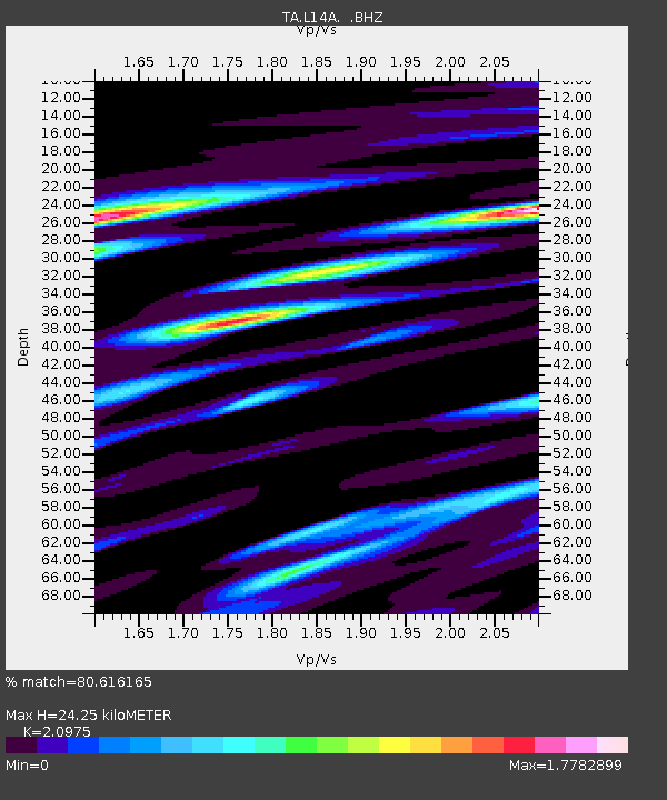
Earthquake location: Andreanof Islands, Aleutian Is.
Earthquake latitude/longitude: 51.6/-174.4
Earthquake time(UTC): 2008/11/02 (307) 13:48:42 GMT
Earthquake Depth: 36 km
Earthquake Magnitude: 5.7 MB, 5.8 MS, 6.1 MW, 6.1 MW
Earthquake Catalog/Contributor: WHDF/NEIC
Network: TA USArray Transportable Network (new EarthScope stations)
Station: L14A Malta, ID, USA
Lat/Lon: 42.03 N/113.24 W
Elevation: 1528 m
Distance: 41.8 deg
Az: 78.266 deg
Baz: 304.857 deg
Ray Param: 0.073495455
Estimated Moho Depth: 24.25 km
Estimated Crust Vp/Vs: 2.10
Assumed Crust Vp: 6.279 km/s
Estimated Crust Vs: 2.993 km/s
Estimated Crust Poisson's Ratio: 0.35
Radial Match: 80.616165 %
Radial Bump: 400
Transverse Match: 61.174038 %
Transverse Bump: 400
SOD ConfigId: 2658
Insert Time: 2010-03-06 15:01:50.587 +0000
GWidth: 2.5
Max Bumps: 400
Tol: 0.001

Signal To Noise

ChannelStoNSTALTA
TA:L14A: :BHZ:20081102T13:55:58.325005Z4.95679477.421855E-71.4973094E-7
TA:L14A: :BHN:20081102T13:55:58.325005Z1.8682053.3512276E-71.7938223E-7
TA:L14A: :BHE:20081102T13:55:58.325005Z1.21313833.1311367E-72.581022E-7
Arrivals
Ps4.5 SECOND
PpPs11 SECOND
PsPs/PpSs16 SECOND