You are here: Home > Network List > AV - Alaska Volcano Observatory Stations List
> Station PLBL Mt. Peulik Volcano, Alaska > Earthquake Result Viewer
PLBL Mt. Peulik Volcano, Alaska - Earthquake Result Viewer
*The percent match for this event was below the threshold and hence no stack was calculated.
| Earthquake location: |
Bonin Islands, Japan Region |
| Earthquake latitude/longitude: |
27.9/139.9 |
| Earthquake time(UTC): |
2018/09/01 (244) 15:43:02 GMT |
| Earthquake Depth: |
455 km |
| Earthquake Magnitude: |
5.6 Mww |
| Earthquake Catalog/Contributor: |
NEIC PDE/us |
|
| Network: |
AV Alaska Volcano Observatory |
| Station: |
PLBL Mt. Peulik Volcano, Alaska |
| Lat/Lon: |
57.70 N/156.82 W |
| Elevation: |
461 m |
|
| Distance: |
52.6 deg |
| Az: |
37.101 deg |
| Baz: |
263.785 deg |
| Ray Param: |
$rayparam |
*The percent match for this event was below the threshold and hence was not used in the summary stack. |
|
| Radial Match: |
48.20129 % |
| Radial Bump: |
400 |
| Transverse Match: |
53.951317 % |
| Transverse Bump: |
400 |
| SOD ConfigId: |
13570011 |
| Insert Time: |
2019-05-01 01:34:07.912 +0000 |
| GWidth: |
2.5 |
| Max Bumps: |
400 |
| Tol: |
0.001 |
|
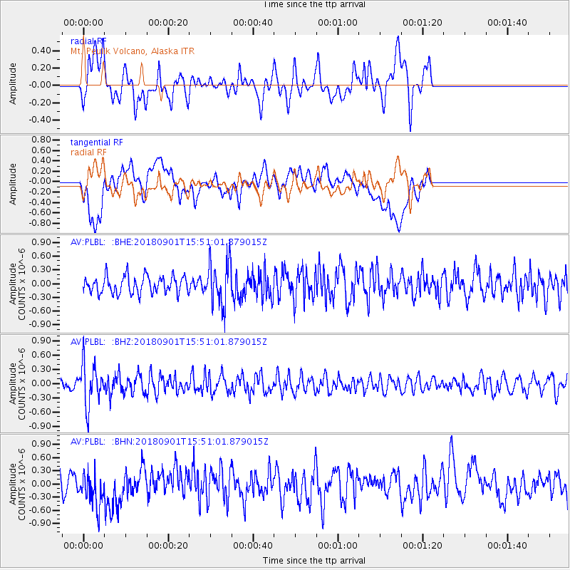
Signal To Noise
| Channel | StoN | STA | LTA |
| AV:PLBL: :BHZ:20180901T15:51:01.879015Z | 3.0860503 | 4.4225513E-7 | 1.4330782E-7 |
| AV:PLBL: :BHN:20180901T15:51:01.879015Z | 1.2435592 | 4.060375E-7 | 3.265124E-7 |
| AV:PLBL: :BHE:20180901T15:51:01.879015Z | 2.5008757 | 4.7134913E-7 | 1.8847363E-7 |
| Arrivals |
| Ps | |
| PpPs | |
| PsPs/PpSs | |


