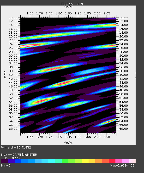
L14A Malta, ID, USA - Earthquake Result Viewer

Earthquake location: Rat Islands, Aleutian Islands
Earthquake latitude/longitude: 51.2/178.8
Earthquake time(UTC): 2008/05/20 (141) 13:53:35 GMT
Earthquake Depth: 27 km
Earthquake Magnitude: 5.8 MB, 6.0 MS, 6.3 MW, 6.3 MW
Earthquake Catalog/Contributor: WHDF/NEIC
Network: TA USArray Transportable Network (new EarthScope stations)
Station: L14A Malta, ID, USA
Lat/Lon: 42.03 N/113.24 W
Elevation: 1528 m
Distance: 46.1 deg
Az: 73.603 deg
Baz: 305.821 deg
Ray Param: 0.07083516
Estimated Moho Depth: 24.75 km
Estimated Crust Vp/Vs: 1.63
Assumed Crust Vp: 6.279 km/s
Estimated Crust Vs: 3.858 km/s
Estimated Crust Poisson's Ratio: 0.20
Radial Match: 86.41852 %
Radial Bump: 400
Transverse Match: 85.289665 %
Transverse Bump: 400
SOD ConfigId: 2504
Insert Time: 2010-03-06 15:03:08.603 +0000
GWidth: 2.5
Max Bumps: 400
Tol: 0.001

Signal To Noise

ChannelStoNSTALTA
TA:L14A: :BHN:20080520T14:01:26.300004Z6.24251037.426065E-71.189596E-7
TA:L14A: :BHE:20080520T14:01:26.300004Z11.8410666.684767E-75.64541E-8
TA:L14A: :BHZ:20080520T14:01:26.300004Z4.0947483.5890176E-78.764929E-8
Arrivals
Ps2.6 SECOND
PpPs9.7 SECOND
PsPs/PpSs12 SECOND