You are here: Home > Network List > CI - Caltech Regional Seismic Network Stations List
> Station PDM Parker Dam, Lake Havasu City, AZ, USA > Earthquake Result Viewer
PDM Parker Dam, Lake Havasu City, AZ, USA - Earthquake Result Viewer

| Earthquake location: |
Near East Coast Of Honshu, Japan |
| Earthquake latitude/longitude: |
38.3/142.0 |
| Earthquake time(UTC): |
2005/08/16 (228) 02:46:28 GMT |
| Earthquake Depth: |
36 km |
| Earthquake Magnitude: |
6.5 MB, 6.8 MS, 7.2 MW, 7.1 MW |
| Earthquake Catalog/Contributor: |
WHDF/NEIC |
|
| Network: |
CI Caltech Regional Seismic Network |
| Station: |
PDM Parker Dam, Lake Havasu City, AZ, USA |
| Lat/Lon: |
34.30 N/114.14 W |
| Elevation: |
144 m |
|
| Distance: |
79.0 deg |
| Az: |
54.969 deg |
| Baz: |
308.875 deg |
| Ray Param: |
0.04919361 |
| Estimated Moho Depth: |
27.5 km |
| Estimated Crust Vp/Vs: |
1.74 |
| Assumed Crust Vp: |
6.276 km/s |
| Estimated Crust Vs: |
3.612 km/s |
| Estimated Crust Poisson's Ratio: |
0.25 |
|
| Radial Match: |
96.385445 % |
| Radial Bump: |
368 |
| Transverse Match: |
87.51418 % |
| Transverse Bump: |
400 |
| SOD ConfigId: |
2475 |
| Insert Time: |
2010-02-26 02:20:21.249 +0000 |
| GWidth: |
2.5 |
| Max Bumps: |
400 |
| Tol: |
0.001 |
|
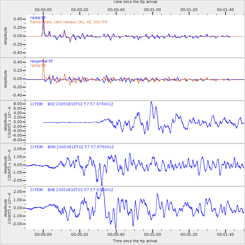
Signal To Noise
| Channel | StoN | STA | LTA |
| CI:PDM: :BHN:20050816T02:57:57.676001Z | 3.423846 | 1.7669824E-7 | 5.1608115E-8 |
| CI:PDM: :BHE:20050816T02:57:57.676001Z | 4.0034285 | 3.538154E-7 | 8.83781E-8 |
| CI:PDM: :BHZ:20050816T02:57:57.676001Z | 10.42513 | 7.1164726E-7 | 6.826268E-8 |
| Arrivals |
| Ps | 3.3 SECOND |
| PpPs | 12 SECOND |
| PsPs/PpSs | 15 SECOND |


