You are here: Home > Network List > TA - USArray Transportable Network (new EarthScope stations) Stations List
> Station B18K Kokolik River, AK, USA > Earthquake Result Viewer
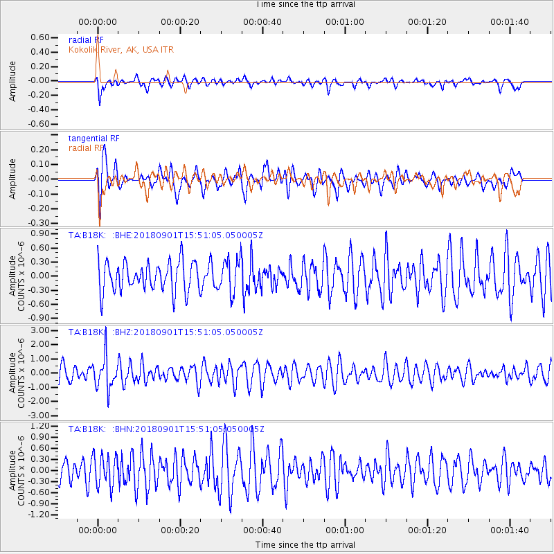
B18K Kokolik River, AK, USA - Earthquake Result Viewer
*The percent match for this event was below the threshold and hence no stack was calculated.
| Earthquake location: |
Bonin Islands, Japan Region |
| Earthquake latitude/longitude: |
27.9/139.9 |
| Earthquake time(UTC): |
2018/09/01 (244) 15:43:02 GMT |
| Earthquake Depth: |
455 km |
| Earthquake Magnitude: |
5.6 Mww |
| Earthquake Catalog/Contributor: |
NEIC PDE/us |
|
| Network: |
TA USArray Transportable Network (new EarthScope stations) |
| Station: |
B18K Kokolik River, AK, USA |
| Lat/Lon: |
69.36 N/161.80 W |
| Elevation: |
222 m |
|
| Distance: |
53.1 deg |
| Az: |
22.152 deg |
| Baz: |
250.249 deg |
| Ray Param: |
$rayparam |
*The percent match for this event was below the threshold and hence was not used in the summary stack. |
|
| Radial Match: |
60.14051 % |
| Radial Bump: |
400 |
| Transverse Match: |
66.05085 % |
| Transverse Bump: |
400 |
| SOD ConfigId: |
13570011 |
| Insert Time: |
2019-05-01 01:39:08.736 +0000 |
| GWidth: |
2.5 |
| Max Bumps: |
400 |
| Tol: |
0.001 |
|
Signal To Noise
| Channel | StoN | STA | LTA |
| TA:B18K: :BHZ:20180901T15:51:05.050005Z | 1.8189129 | 1.1689679E-6 | 6.426739E-7 |
| TA:B18K: :BHN:20180901T15:51:05.050005Z | 0.9204546 | 4.1270914E-7 | 4.4837535E-7 |
| TA:B18K: :BHE:20180901T15:51:05.050005Z | 1.1514328 | 3.60012E-7 | 3.1266438E-7 |
| Arrivals |
| Ps | |
| PpPs | |
| PsPs/PpSs | |


