You are here: Home > Network List > TA - USArray Transportable Network (new EarthScope stations) Stations List
> Station G31M Satah River, YT, CAN > Earthquake Result Viewer
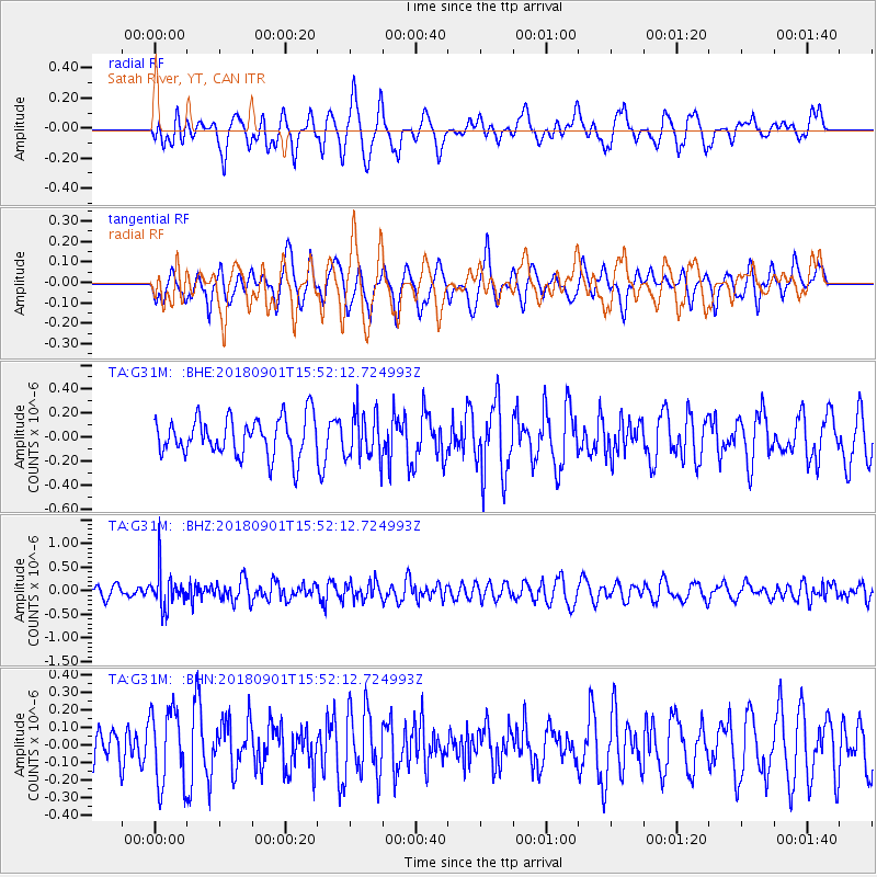
G31M Satah River, YT, CAN - Earthquake Result Viewer
*The percent match for this event was below the threshold and hence no stack was calculated.
| Earthquake location: |
Bonin Islands, Japan Region |
| Earthquake latitude/longitude: |
27.9/139.9 |
| Earthquake time(UTC): |
2018/09/01 (244) 15:43:02 GMT |
| Earthquake Depth: |
455 km |
| Earthquake Magnitude: |
5.6 Mww |
| Earthquake Catalog/Contributor: |
NEIC PDE/us |
|
| Network: |
TA USArray Transportable Network (new EarthScope stations) |
| Station: |
G31M Satah River, YT, CAN |
| Lat/Lon: |
66.92 N/134.27 W |
| Elevation: |
61 m |
|
| Distance: |
63.0 deg |
| Az: |
26.179 deg |
| Baz: |
277.991 deg |
| Ray Param: |
$rayparam |
*The percent match for this event was below the threshold and hence was not used in the summary stack. |
|
| Radial Match: |
54.136654 % |
| Radial Bump: |
400 |
| Transverse Match: |
53.541622 % |
| Transverse Bump: |
400 |
| SOD ConfigId: |
13570011 |
| Insert Time: |
2019-05-01 01:39:49.136 +0000 |
| GWidth: |
2.5 |
| Max Bumps: |
400 |
| Tol: |
0.001 |
|
Signal To Noise
| Channel | StoN | STA | LTA |
| TA:G31M: :BHZ:20180901T15:52:12.724993Z | 2.4638588 | 3.8951404E-7 | 1.5809105E-7 |
| TA:G31M: :BHN:20180901T15:52:12.724993Z | 1.2713388 | 2.1215726E-7 | 1.6687704E-7 |
| TA:G31M: :BHE:20180901T15:52:12.724993Z | 1.153928 | 1.8658626E-7 | 1.6169662E-7 |
| Arrivals |
| Ps | |
| PpPs | |
| PsPs/PpSs | |


