You are here: Home > Network List > TA - USArray Transportable Network (new EarthScope stations) Stations List
> Station L14A Malta, ID, USA > Earthquake Result Viewer
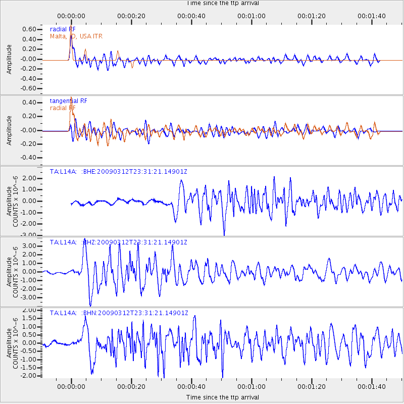
L14A Malta, ID, USA - Earthquake Result Viewer
*The percent match for this event was below the threshold and hence no stack was calculated.
| Earthquake location: |
South Of Panama |
| Earthquake latitude/longitude: |
5.7/-82.8 |
| Earthquake time(UTC): |
2009/03/12 (071) 23:23:34 GMT |
| Earthquake Depth: |
9.0 km |
| Earthquake Magnitude: |
6.1 MB, 5.9 MS, 6.3 MW, 6.2 MW |
| Earthquake Catalog/Contributor: |
WHDF/NEIC |
|
| Network: |
TA USArray Transportable Network (new EarthScope stations) |
| Station: |
L14A Malta, ID, USA |
| Lat/Lon: |
42.03 N/113.24 W |
| Elevation: |
1528 m |
|
| Distance: |
45.2 deg |
| Az: |
327.831 deg |
| Baz: |
134.667 deg |
| Ray Param: |
$rayparam |
*The percent match for this event was below the threshold and hence was not used in the summary stack. |
|
| Radial Match: |
78.5502 % |
| Radial Bump: |
400 |
| Transverse Match: |
73.8199 % |
| Transverse Bump: |
400 |
| SOD ConfigId: |
2658 |
| Insert Time: |
2010-03-06 15:04:16.934 +0000 |
| GWidth: |
2.5 |
| Max Bumps: |
400 |
| Tol: |
0.001 |
|
Signal To Noise
| Channel | StoN | STA | LTA |
| TA:L14A: :BHZ:20090312T23:31:21.14901Z | 12.361557 | 1.5137175E-6 | 1.2245363E-7 |
| TA:L14A: :BHN:20090312T23:31:21.14901Z | 5.7189493 | 5.960685E-7 | 1.0422692E-7 |
| TA:L14A: :BHE:20090312T23:31:21.14901Z | 3.7287433 | 5.8570174E-7 | 1.5707752E-7 |
| Arrivals |
| Ps | |
| PpPs | |
| PsPs/PpSs | |


