You are here: Home > Network List > UW - Pacific Northwest Regional Seismic Network Stations List
> Station FISH Seaside, OR, USA > Earthquake Result Viewer
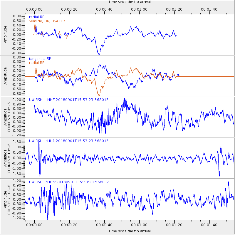
FISH Seaside, OR, USA - Earthquake Result Viewer
*The percent match for this event was below the threshold and hence no stack was calculated.
| Earthquake location: |
Bonin Islands, Japan Region |
| Earthquake latitude/longitude: |
27.9/139.9 |
| Earthquake time(UTC): |
2018/09/01 (244) 15:43:02 GMT |
| Earthquake Depth: |
455 km |
| Earthquake Magnitude: |
5.6 Mww |
| Earthquake Catalog/Contributor: |
NEIC PDE/us |
|
| Network: |
UW Pacific Northwest Regional Seismic Network |
| Station: |
FISH Seaside, OR, USA |
| Lat/Lon: |
45.93 N/123.56 W |
| Elevation: |
325 m |
|
| Distance: |
74.7 deg |
| Az: |
45.964 deg |
| Baz: |
294.293 deg |
| Ray Param: |
$rayparam |
*The percent match for this event was below the threshold and hence was not used in the summary stack. |
|
| Radial Match: |
23.155005 % |
| Radial Bump: |
400 |
| Transverse Match: |
35.624756 % |
| Transverse Bump: |
400 |
| SOD ConfigId: |
13570011 |
| Insert Time: |
2019-05-01 01:42:02.114 +0000 |
| GWidth: |
2.5 |
| Max Bumps: |
400 |
| Tol: |
0.001 |
|
Signal To Noise
| Channel | StoN | STA | LTA |
| UW:FISH: :HHZ:20180901T15:53:23.56801Z | 4.1062574 | 6.5526035E-7 | 1.5957605E-7 |
| UW:FISH: :HHN:20180901T15:53:23.56801Z | 1.256437 | 3.2503132E-7 | 2.586929E-7 |
| UW:FISH: :HHE:20180901T15:53:23.56801Z | 1.9551917 | 5.739548E-7 | 2.9355422E-7 |
| Arrivals |
| Ps | |
| PpPs | |
| PsPs/PpSs | |


