You are here: Home > Network List > UW - Pacific Northwest Regional Seismic Network Stations List
> Station HOOD Mt Hood Meadows, OR CREST BB SMO > Earthquake Result Viewer
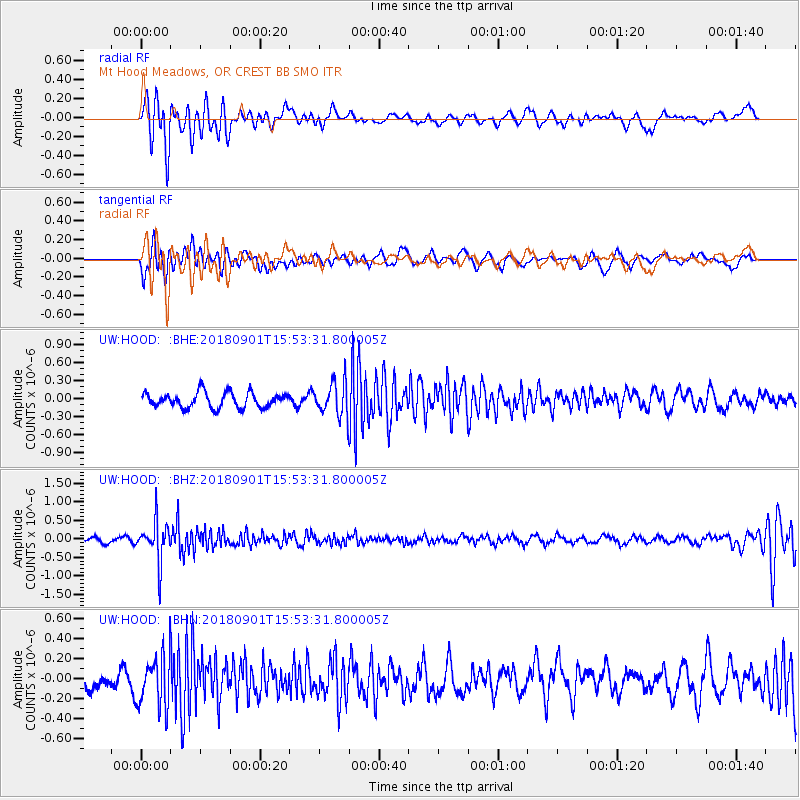
HOOD Mt Hood Meadows, OR CREST BB SMO - Earthquake Result Viewer
*The percent match for this event was below the threshold and hence no stack was calculated.
| Earthquake location: |
Bonin Islands, Japan Region |
| Earthquake latitude/longitude: |
27.9/139.9 |
| Earthquake time(UTC): |
2018/09/01 (244) 15:43:02 GMT |
| Earthquake Depth: |
455 km |
| Earthquake Magnitude: |
5.6 Mww |
| Earthquake Catalog/Contributor: |
NEIC PDE/us |
|
| Network: |
UW Pacific Northwest Regional Seismic Network |
| Station: |
HOOD Mt Hood Meadows, OR CREST BB SMO |
| Lat/Lon: |
45.32 N/121.65 W |
| Elevation: |
1520 m |
|
| Distance: |
76.2 deg |
| Az: |
45.952 deg |
| Baz: |
295.648 deg |
| Ray Param: |
$rayparam |
*The percent match for this event was below the threshold and hence was not used in the summary stack. |
|
| Radial Match: |
67.26082 % |
| Radial Bump: |
400 |
| Transverse Match: |
61.26465 % |
| Transverse Bump: |
400 |
| SOD ConfigId: |
13570011 |
| Insert Time: |
2019-05-01 01:42:04.557 +0000 |
| GWidth: |
2.5 |
| Max Bumps: |
400 |
| Tol: |
0.001 |
|
Signal To Noise
| Channel | StoN | STA | LTA |
| UW:HOOD: :BHZ:20180901T15:53:31.800005Z | 7.3343573 | 5.3267803E-7 | 7.262778E-8 |
| UW:HOOD: :BHN:20180901T15:53:31.800005Z | 2.7991965 | 2.5832287E-7 | 9.2284644E-8 |
| UW:HOOD: :BHE:20180901T15:53:31.800005Z | 2.0896435 | 2.6123683E-7 | 1.2501502E-7 |
| Arrivals |
| Ps | |
| PpPs | |
| PsPs/PpSs | |


