You are here: Home > Network List > CO - South Carolina Seismic Network Stations List
> Station PAULI CO:PAULI > Earthquake Result Viewer
PAULI CO:PAULI - Earthquake Result Viewer
| Earthquake location: |
Near Coast Of Ecuador |
| Earthquake latitude/longitude: |
0.6/-79.7 |
| Earthquake time(UTC): |
2016/07/11 (193) 02:11:04 GMT |
| Earthquake Depth: |
19 km |
| Earthquake Magnitude: |
6.3 MWW, 6.3 MWC, 6.3 MWB |
| Earthquake Catalog/Contributor: |
NEIC PDE/NEIC COMCAT |
|
| Network: |
CO South Carolina Seismic Network |
| Station: |
PAULI CO:PAULI |
| Lat/Lon: |
34.82 N/81.81 W |
| Elevation: |
179 m |
|
| Distance: |
34.1 deg |
| Az: |
356.846 deg |
| Baz: |
176.166 deg |
| Ray Param: |
0.07786045 |
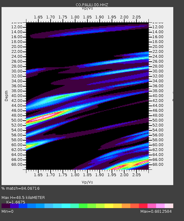
| Estimated Moho Depth: |
48.5 km |
| Estimated Crust Vp/Vs: |
1.67 |
| Assumed Crust Vp: |
6.419 km/s |
| Estimated Crust Vs: |
3.85 km/s |
| Estimated Crust Poisson's Ratio: |
0.22 |
|
| Radial Match: |
84.06716 % |
| Radial Bump: |
400 |
| Transverse Match: |
75.12784 % |
| Transverse Bump: |
400 |
| SOD ConfigId: |
1634031 |
| Insert Time: |
2016-07-25 02:25:06.493 +0000 |
| GWidth: |
2.5 |
| Max Bumps: |
400 |
| Tol: |
0.001 |
|

Signal To Noise
| Channel | StoN | STA | LTA |
| CO:PAULI:00:HHZ:20160711T02:17:17.519998Z | 2.5597858 | 1.0482778E-6 | 4.0951775E-7 |
| CO:PAULI:00:HHN:20160711T02:17:17.519998Z | 5.214411 | 8.422617E-7 | 1.6152576E-7 |
| CO:PAULI:00:HHE:20160711T02:17:17.519998Z | 1.0142905 | 1.1212172E-6 | 1.1054203E-6 |
| Arrivals |
| Ps | 5.5 SECOND |
| PpPs | 19 SECOND |
| PsPs/PpSs | 24 SECOND |


