You are here: Home > Network List > TA - USArray Transportable Network (new EarthScope stations) Stations List
> Station L14A Malta, ID, USA > Earthquake Result Viewer
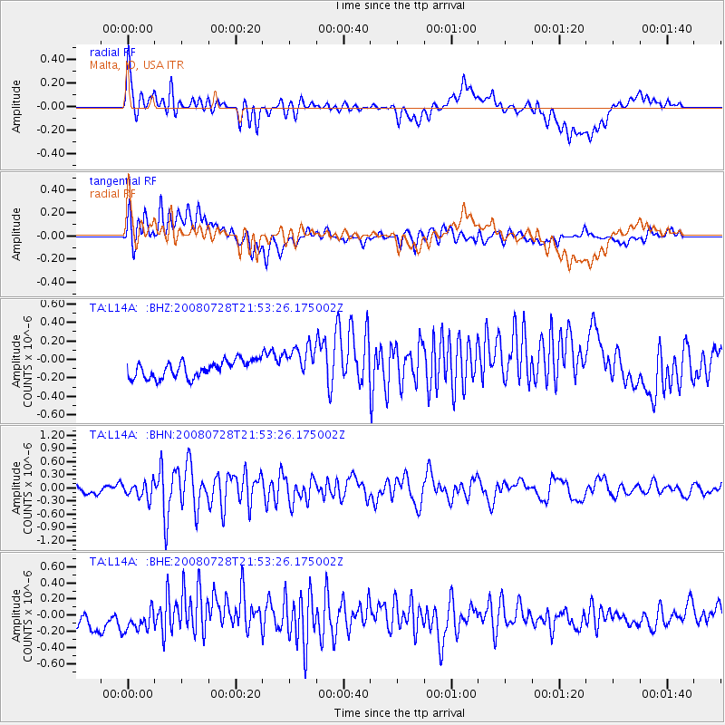
L14A Malta, ID, USA - Earthquake Result Viewer
*The percent match for this event was below the threshold and hence no stack was calculated.
| Earthquake location: |
Solomon Islands |
| Earthquake latitude/longitude: |
-10.6/163.1 |
| Earthquake time(UTC): |
2008/07/28 (210) 21:40:47 GMT |
| Earthquake Depth: |
10 km |
| Earthquake Magnitude: |
5.9 MB, 5.8 MS, 6.0 MW |
| Earthquake Catalog/Contributor: |
WHDF/NEIC |
|
| Network: |
TA USArray Transportable Network (new EarthScope stations) |
| Station: |
L14A Malta, ID, USA |
| Lat/Lon: |
42.03 N/113.24 W |
| Elevation: |
1528 m |
|
| Distance: |
92.3 deg |
| Az: |
47.819 deg |
| Baz: |
257.965 deg |
| Ray Param: |
$rayparam |
*The percent match for this event was below the threshold and hence was not used in the summary stack. |
|
| Radial Match: |
62.811356 % |
| Radial Bump: |
400 |
| Transverse Match: |
51.928444 % |
| Transverse Bump: |
400 |
| SOD ConfigId: |
2504 |
| Insert Time: |
2010-03-06 15:05:00.775 +0000 |
| GWidth: |
2.5 |
| Max Bumps: |
400 |
| Tol: |
0.001 |
|
Signal To Noise
| Channel | StoN | STA | LTA |
| TA:L14A: :BHN:20080728T21:53:26.175002Z | 2.1813042 | 1.8056089E-7 | 8.2776566E-8 |
| TA:L14A: :BHE:20080728T21:53:26.175002Z | 1.3567126 | 1.6921456E-7 | 1.2472395E-7 |
| TA:L14A: :BHZ:20080728T21:53:26.175002Z | 2.0850854 | 1.880939E-7 | 9.0209205E-8 |
| Arrivals |
| Ps | |
| PpPs | |
| PsPs/PpSs | |


