You are here: Home > Network List > ET - CERI Southern Appalachian seismic Network Stations List
> Station SWET Sewanee,TN > Earthquake Result Viewer
SWET Sewanee,TN - Earthquake Result Viewer
| Earthquake location: |
Near Coast Of Ecuador |
| Earthquake latitude/longitude: |
0.6/-79.7 |
| Earthquake time(UTC): |
2016/07/11 (193) 02:11:04 GMT |
| Earthquake Depth: |
19 km |
| Earthquake Magnitude: |
6.3 MWW, 6.3 MWC, 6.3 MWB |
| Earthquake Catalog/Contributor: |
NEIC PDE/NEIC COMCAT |
|
| Network: |
ET CERI Southern Appalachian seismic Network |
| Station: |
SWET Sewanee,TN |
| Lat/Lon: |
35.22 N/85.93 W |
| Elevation: |
581 m |
|
| Distance: |
35.0 deg |
| Az: |
351.027 deg |
| Baz: |
169.019 deg |
| Ray Param: |
0.07744139 |
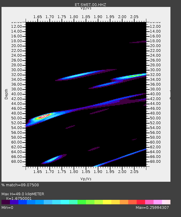
| Estimated Moho Depth: |
49.0 km |
| Estimated Crust Vp/Vs: |
1.68 |
| Assumed Crust Vp: |
6.35 km/s |
| Estimated Crust Vs: |
3.791 km/s |
| Estimated Crust Poisson's Ratio: |
0.22 |
|
| Radial Match: |
89.07508 % |
| Radial Bump: |
290 |
| Transverse Match: |
49.815556 % |
| Transverse Bump: |
332 |
| SOD ConfigId: |
1634031 |
| Insert Time: |
2016-07-25 02:25:31.025 +0000 |
| GWidth: |
2.5 |
| Max Bumps: |
400 |
| Tol: |
0.001 |
|

Signal To Noise
| Channel | StoN | STA | LTA |
| ET:SWET:00:HHZ:20160711T02:17:24.660012Z | 5.5922 | 1.3230047E-6 | 2.3658038E-7 |
| ET:SWET:00:HHN:20160711T02:17:24.660012Z | 2.9104395 | 9.771447E-7 | 3.3573787E-7 |
| ET:SWET:00:HHE:20160711T02:17:24.660012Z | 0.88937265 | 7.196655E-7 | 8.091833E-7 |
| Arrivals |
| Ps | 5.6 SECOND |
| PpPs | 19 SECOND |
| PsPs/PpSs | 25 SECOND |


