You are here: Home > Network List > TA - USArray Transportable Network (new EarthScope stations) Stations List
> Station O17A Robinson Place, Fruitland, UT, USA > Earthquake Result Viewer
O17A Robinson Place, Fruitland, UT, USA - Earthquake Result Viewer
| Earthquake location: |
Kermadec Islands Region |
| Earthquake latitude/longitude: |
-27.4/-176.3 |
| Earthquake time(UTC): |
2009/02/18 (049) 21:53:45 GMT |
| Earthquake Depth: |
25 km |
| Earthquake Magnitude: |
6.8 MB, 7.2 MS, 6.9 MW, 6.9 MW |
| Earthquake Catalog/Contributor: |
WHDF/NEIC |
|
| Network: |
TA USArray Transportable Network (new EarthScope stations) |
| Station: |
O17A Robinson Place, Fruitland, UT, USA |
| Lat/Lon: |
40.19 N/110.74 W |
| Elevation: |
2079 m |
|
| Distance: |
90.8 deg |
| Az: |
44.234 deg |
| Baz: |
234.048 deg |
| Ray Param: |
0.041648313 |
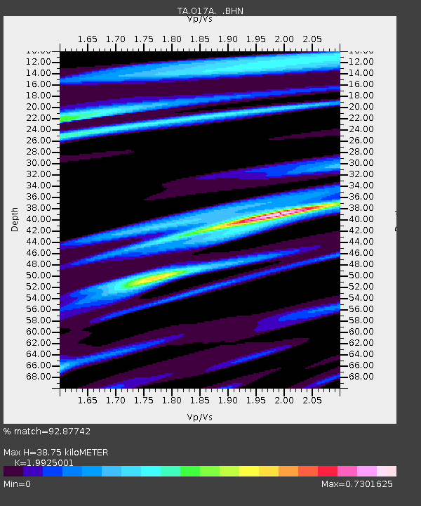
| Estimated Moho Depth: |
38.75 km |
| Estimated Crust Vp/Vs: |
1.99 |
| Assumed Crust Vp: |
6.155 km/s |
| Estimated Crust Vs: |
3.089 km/s |
| Estimated Crust Poisson's Ratio: |
0.33 |
|
| Radial Match: |
92.87742 % |
| Radial Bump: |
356 |
| Transverse Match: |
84.21609 % |
| Transverse Bump: |
400 |
| SOD ConfigId: |
2658 |
| Insert Time: |
2010-03-06 15:05:53.894 +0000 |
| GWidth: |
2.5 |
| Max Bumps: |
400 |
| Tol: |
0.001 |
|

Signal To Noise
| Channel | StoN | STA | LTA |
| TA:O17A: :BHN:20090218T22:06:14.449001Z | 11.171446 | 1.8810289E-6 | 1.6837828E-7 |
| TA:O17A: :BHE:20090218T22:06:14.449001Z | 1.7590512 | 3.983606E-7 | 2.2646334E-7 |
| TA:O17A: :BHZ:20090218T22:06:14.449001Z | 2.5431845 | 5.710111E-7 | 2.2452605E-7 |
| Arrivals |
| Ps | 6.4 SECOND |
| PpPs | 19 SECOND |
| PsPs/PpSs | 25 SECOND |


