You are here: Home > Network List > TA - USArray Transportable Network (new EarthScope stations) Stations List
> Station D23K Nanushuk River, AK USA > Earthquake Result Viewer
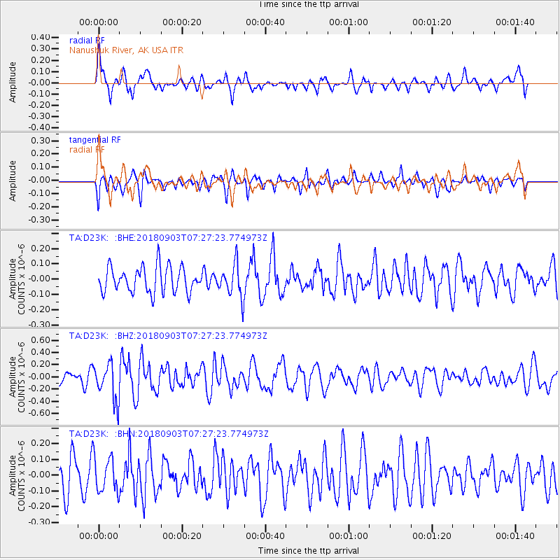
D23K Nanushuk River, AK USA - Earthquake Result Viewer
*The percent match for this event was below the threshold and hence no stack was calculated.
| Earthquake location: |
New Ireland Region, P.N.G. |
| Earthquake latitude/longitude: |
-3.8/150.2 |
| Earthquake time(UTC): |
2018/09/03 (246) 07:15:30 GMT |
| Earthquake Depth: |
10 km |
| Earthquake Magnitude: |
5.5 Mww |
| Earthquake Catalog/Contributor: |
NEIC PDE/us |
|
| Network: |
TA USArray Transportable Network (new EarthScope stations) |
| Station: |
D23K Nanushuk River, AK USA |
| Lat/Lon: |
68.97 N/150.68 W |
| Elevation: |
406 m |
|
| Distance: |
82.9 deg |
| Az: |
18.194 deg |
| Baz: |
239.645 deg |
| Ray Param: |
$rayparam |
*The percent match for this event was below the threshold and hence was not used in the summary stack. |
|
| Radial Match: |
60.336765 % |
| Radial Bump: |
400 |
| Transverse Match: |
59.247883 % |
| Transverse Bump: |
400 |
| SOD ConfigId: |
13570011 |
| Insert Time: |
2019-05-01 01:52:49.609 +0000 |
| GWidth: |
2.5 |
| Max Bumps: |
400 |
| Tol: |
0.001 |
|
Signal To Noise
| Channel | StoN | STA | LTA |
| TA:D23K: :BHZ:20180903T07:27:23.774973Z | 2.5299585 | 3.079122E-7 | 1.2170642E-7 |
| TA:D23K: :BHN:20180903T07:27:23.774973Z | 0.9200048 | 9.970711E-8 | 1.0837673E-7 |
| TA:D23K: :BHE:20180903T07:27:23.774973Z | 1.3783729 | 1.13953696E-7 | 8.267262E-8 |
| Arrivals |
| Ps | |
| PpPs | |
| PsPs/PpSs | |


