You are here: Home > Network List > TA - USArray Transportable Network (new EarthScope stations) Stations List
> Station O17A Robinson Place, Fruitland, UT, USA > Earthquake Result Viewer
O17A Robinson Place, Fruitland, UT, USA - Earthquake Result Viewer

| Earthquake location: |
Southeast Of Loyalty Islands |
| Earthquake latitude/longitude: |
-21.2/169.4 |
| Earthquake time(UTC): |
2007/09/27 (270) 21:05:33 GMT |
| Earthquake Depth: |
10 km |
| Earthquake Magnitude: |
5.5 MS, 5.4 MB |
| Earthquake Catalog/Contributor: |
WHDF/NEIC |
|
| Network: |
TA USArray Transportable Network (new EarthScope stations) |
| Station: |
O17A Robinson Place, Fruitland, UT, USA |
| Lat/Lon: |
40.19 N/110.74 W |
| Elevation: |
2079 m |
|
| Distance: |
96.1 deg |
| Az: |
49.314 deg |
| Baz: |
247.476 deg |
| Ray Param: |
0.040617716 |
| Estimated Moho Depth: |
60.5 km |
| Estimated Crust Vp/Vs: |
1.73 |
| Assumed Crust Vp: |
6.155 km/s |
| Estimated Crust Vs: |
3.553 km/s |
| Estimated Crust Poisson's Ratio: |
0.25 |
|
| Radial Match: |
84.81433 % |
| Radial Bump: |
400 |
| Transverse Match: |
56.567333 % |
| Transverse Bump: |
400 |
| SOD ConfigId: |
2564 |
| Insert Time: |
2010-03-06 15:06:07.526 +0000 |
| GWidth: |
2.5 |
| Max Bumps: |
400 |
| Tol: |
0.001 |
|
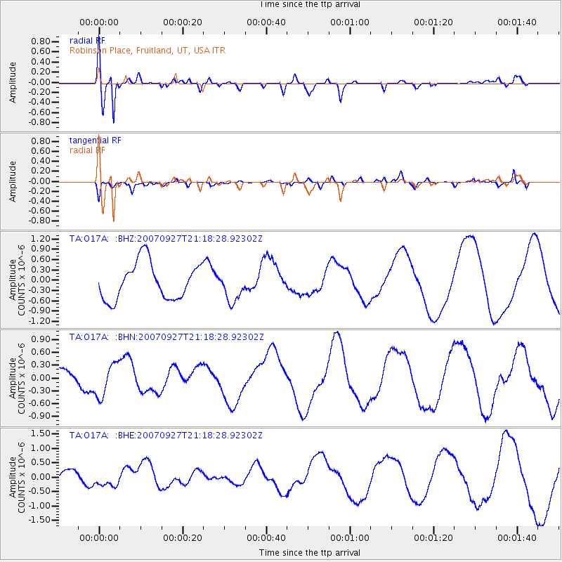
Signal To Noise
| Channel | StoN | STA | LTA |
| TA:O17A: :BHN:20070927T21:18:28.92302Z | 1.8087975 | 3.918003E-7 | 2.1660819E-7 |
| TA:O17A: :BHE:20070927T21:18:28.92302Z | 0.4881138 | 1.7594127E-7 | 3.6045134E-7 |
| TA:O17A: :BHZ:20070927T21:18:28.92302Z | 0.852079 | 4.5477967E-7 | 5.3372946E-7 |
| Arrivals |
| Ps | 7.3 SECOND |
| PpPs | 26 SECOND |
| PsPs/PpSs | 34 SECOND |


