You are here: Home > Network List > TA - USArray Transportable Network (new EarthScope stations) Stations List
> Station O17A Robinson Place, Fruitland, UT, USA > Earthquake Result Viewer
O17A Robinson Place, Fruitland, UT, USA - Earthquake Result Viewer
| Earthquake location: |
Tonga Islands |
| Earthquake latitude/longitude: |
-17.5/-174.3 |
| Earthquake time(UTC): |
2007/08/26 (238) 12:37:31 GMT |
| Earthquake Depth: |
127 km |
| Earthquake Magnitude: |
5.9 MB, 6.1 MW |
| Earthquake Catalog/Contributor: |
WHDF/NEIC |
|
| Network: |
TA USArray Transportable Network (new EarthScope stations) |
| Station: |
O17A Robinson Place, Fruitland, UT, USA |
| Lat/Lon: |
40.19 N/110.74 W |
| Elevation: |
2079 m |
|
| Distance: |
82.3 deg |
| Az: |
43.811 deg |
| Baz: |
239.617 deg |
| Ray Param: |
0.046673376 |
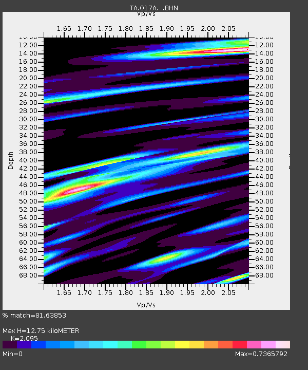
| Estimated Moho Depth: |
12.75 km |
| Estimated Crust Vp/Vs: |
2.10 |
| Assumed Crust Vp: |
6.155 km/s |
| Estimated Crust Vs: |
2.938 km/s |
| Estimated Crust Poisson's Ratio: |
0.35 |
|
| Radial Match: |
81.63853 % |
| Radial Bump: |
400 |
| Transverse Match: |
78.47812 % |
| Transverse Bump: |
400 |
| SOD ConfigId: |
2564 |
| Insert Time: |
2010-03-06 15:06:10.732 +0000 |
| GWidth: |
2.5 |
| Max Bumps: |
400 |
| Tol: |
0.001 |
|

Signal To Noise
| Channel | StoN | STA | LTA |
| TA:O17A: :BHN:20070826T12:49:07.624021Z | 2.095643 | 1.5932291E-7 | 7.6025785E-8 |
| TA:O17A: :BHE:20070826T12:49:07.624021Z | 4.5174947 | 2.214227E-7 | 4.9014492E-8 |
| TA:O17A: :BHZ:20070826T12:49:07.624021Z | 9.121827 | 1.0388411E-6 | 1.1388519E-7 |
| Arrivals |
| Ps | 2.3 SECOND |
| PpPs | 6.3 SECOND |
| PsPs/PpSs | 8.6 SECOND |


