You are here: Home > Network List > TA - USArray Transportable Network (new EarthScope stations) Stations List
> Station J26L Joseph Creek, AK, USA > Earthquake Result Viewer
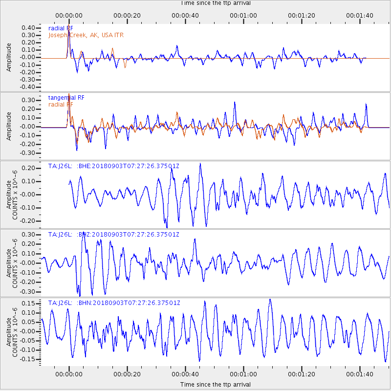
J26L Joseph Creek, AK, USA - Earthquake Result Viewer
*The percent match for this event was below the threshold and hence no stack was calculated.
| Earthquake location: |
New Ireland Region, P.N.G. |
| Earthquake latitude/longitude: |
-3.8/150.2 |
| Earthquake time(UTC): |
2018/09/03 (246) 07:15:30 GMT |
| Earthquake Depth: |
10 km |
| Earthquake Magnitude: |
5.5 Mww |
| Earthquake Catalog/Contributor: |
NEIC PDE/us |
|
| Network: |
TA USArray Transportable Network (new EarthScope stations) |
| Station: |
J26L Joseph Creek, AK, USA |
| Lat/Lon: |
64.50 N/143.56 W |
| Elevation: |
1144 m |
|
| Distance: |
83.4 deg |
| Az: |
23.501 deg |
| Baz: |
246.813 deg |
| Ray Param: |
$rayparam |
*The percent match for this event was below the threshold and hence was not used in the summary stack. |
|
| Radial Match: |
64.82978 % |
| Radial Bump: |
400 |
| Transverse Match: |
66.493706 % |
| Transverse Bump: |
400 |
| SOD ConfigId: |
13570011 |
| Insert Time: |
2019-05-01 01:53:27.695 +0000 |
| GWidth: |
2.5 |
| Max Bumps: |
400 |
| Tol: |
0.001 |
|
Signal To Noise
| Channel | StoN | STA | LTA |
| TA:J26L: :BHZ:20180903T07:27:26.37501Z | 3.4262834 | 1.6371249E-7 | 4.7781363E-8 |
| TA:J26L: :BHN:20180903T07:27:26.37501Z | 1.6561397 | 8.000329E-8 | 4.830709E-8 |
| TA:J26L: :BHE:20180903T07:27:26.37501Z | 2.4892104 | 1.2182107E-7 | 4.893965E-8 |
| Arrivals |
| Ps | |
| PpPs | |
| PsPs/PpSs | |


