You are here: Home > Network List > TA - USArray Transportable Network (new EarthScope stations) Stations List
> Station O17A Robinson Place, Fruitland, UT, USA > Earthquake Result Viewer
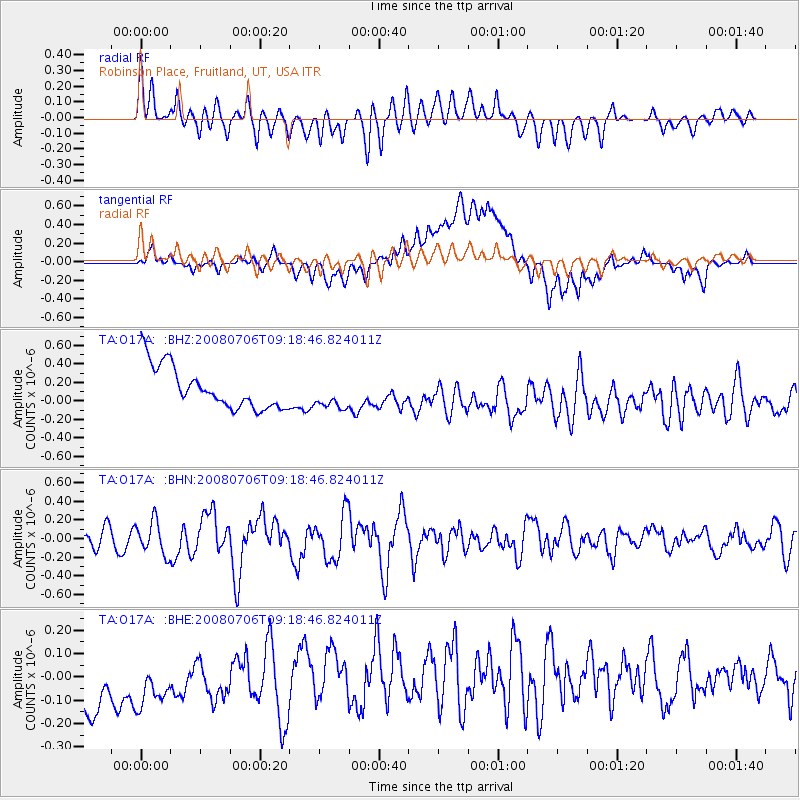
O17A Robinson Place, Fruitland, UT, USA - Earthquake Result Viewer
*The percent match for this event was below the threshold and hence no stack was calculated.
| Earthquake location: |
Kuril Islands |
| Earthquake latitude/longitude: |
45.4/151.0 |
| Earthquake time(UTC): |
2008/07/06 (188) 09:08:20 GMT |
| Earthquake Depth: |
10 km |
| Earthquake Magnitude: |
5.8 MB, 5.4 MS, 5.7 MW, 5.7 MW |
| Earthquake Catalog/Contributor: |
WHDF/NEIC |
|
| Network: |
TA USArray Transportable Network (new EarthScope stations) |
| Station: |
O17A Robinson Place, Fruitland, UT, USA |
| Lat/Lon: |
40.19 N/110.74 W |
| Elevation: |
2079 m |
|
| Distance: |
67.8 deg |
| Az: |
54.96 deg |
| Baz: |
311.129 deg |
| Ray Param: |
$rayparam |
*The percent match for this event was below the threshold and hence was not used in the summary stack. |
|
| Radial Match: |
63.017303 % |
| Radial Bump: |
400 |
| Transverse Match: |
40.264725 % |
| Transverse Bump: |
400 |
| SOD ConfigId: |
2504 |
| Insert Time: |
2010-03-06 15:06:50.833 +0000 |
| GWidth: |
2.5 |
| Max Bumps: |
400 |
| Tol: |
0.001 |
|
Signal To Noise
| Channel | StoN | STA | LTA |
| TA:O17A: :BHN:20080706T09:18:46.824011Z | 1.5893027 | 1.7753304E-7 | 1.11704985E-7 |
| TA:O17A: :BHE:20080706T09:18:46.824011Z | 0.74949914 | 2.7881322E-7 | 3.719994E-7 |
| TA:O17A: :BHZ:20080706T09:18:46.824011Z | 0.72586715 | 1.6343755E-7 | 2.2516178E-7 |
| Arrivals |
| Ps | |
| PpPs | |
| PsPs/PpSs | |


