You are here: Home > Network List > TA - USArray Transportable Network (new EarthScope stations) Stations List
> Station O17A Robinson Place, Fruitland, UT, USA > Earthquake Result Viewer
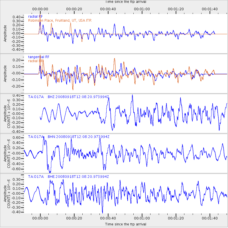
O17A Robinson Place, Fruitland, UT, USA - Earthquake Result Viewer
*The percent match for this event was below the threshold and hence no stack was calculated.
| Earthquake location: |
Near East Coast Of Kamchatka |
| Earthquake latitude/longitude: |
51.9/158.4 |
| Earthquake time(UTC): |
2008/09/18 (262) 11:58:50 GMT |
| Earthquake Depth: |
67 km |
| Earthquake Magnitude: |
5.7 MB, 5.9 MW, 5.8 MW |
| Earthquake Catalog/Contributor: |
WHDF/NEIC |
|
| Network: |
TA USArray Transportable Network (new EarthScope stations) |
| Station: |
O17A Robinson Place, Fruitland, UT, USA |
| Lat/Lon: |
40.19 N/110.74 W |
| Elevation: |
2079 m |
|
| Distance: |
60.2 deg |
| Az: |
61.994 deg |
| Baz: |
314.451 deg |
| Ray Param: |
$rayparam |
*The percent match for this event was below the threshold and hence was not used in the summary stack. |
|
| Radial Match: |
53.078922 % |
| Radial Bump: |
400 |
| Transverse Match: |
47.80334 % |
| Transverse Bump: |
400 |
| SOD ConfigId: |
2560 |
| Insert Time: |
2010-03-06 15:07:10.425 +0000 |
| GWidth: |
2.5 |
| Max Bumps: |
400 |
| Tol: |
0.001 |
|
Signal To Noise
| Channel | StoN | STA | LTA |
| TA:O17A: :BHN:20080918T12:08:20.973994Z | 3.2618425 | 3.5318658E-7 | 1.0827824E-7 |
| TA:O17A: :BHE:20080918T12:08:20.973994Z | 1.8285892 | 1.2914958E-7 | 7.062799E-8 |
| TA:O17A: :BHZ:20080918T12:08:20.973994Z | 0.5254167 | 5.3162044E-8 | 1.0118073E-7 |
| Arrivals |
| Ps | |
| PpPs | |
| PsPs/PpSs | |


