You are here: Home > Network List > IW - Intermountain West Stations List
> Station MOOW Moose Ponds, Wyoming, USA > Earthquake Result Viewer
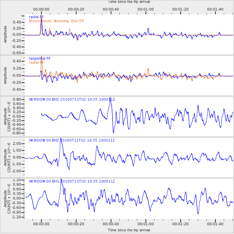
MOOW Moose Ponds, Wyoming, USA - Earthquake Result Viewer
*The percent match for this event was below the threshold and hence no stack was calculated.
| Earthquake location: |
Near Coast Of Ecuador |
| Earthquake latitude/longitude: |
0.6/-79.7 |
| Earthquake time(UTC): |
2016/07/11 (193) 02:11:04 GMT |
| Earthquake Depth: |
19 km |
| Earthquake Magnitude: |
6.3 MWW, 6.3 MWC, 6.3 MWB |
| Earthquake Catalog/Contributor: |
NEIC PDE/NEIC COMCAT |
|
| Network: |
IW Intermountain West |
| Station: |
MOOW Moose Ponds, Wyoming, USA |
| Lat/Lon: |
43.75 N/110.74 W |
| Elevation: |
2128 m |
|
| Distance: |
51.2 deg |
| Az: |
331.29 deg |
| Baz: |
138.483 deg |
| Ray Param: |
$rayparam |
*The percent match for this event was below the threshold and hence was not used in the summary stack. |
|
| Radial Match: |
77.96418 % |
| Radial Bump: |
400 |
| Transverse Match: |
60.88198 % |
| Transverse Bump: |
400 |
| SOD ConfigId: |
1634031 |
| Insert Time: |
2016-07-25 02:31:12.518 +0000 |
| GWidth: |
2.5 |
| Max Bumps: |
400 |
| Tol: |
0.001 |
|
Signal To Noise
| Channel | StoN | STA | LTA |
| IW:MOOW:00:BHZ:20160711T02:19:35.190011Z | 3.593463 | 3.7004446E-7 | 1.02977125E-7 |
| IW:MOOW:00:BH1:20160711T02:19:35.190011Z | 2.5547645 | 2.6542858E-7 | 1.03895516E-7 |
| IW:MOOW:00:BH2:20160711T02:19:35.190011Z | 2.3274608 | 2.7903553E-7 | 1.198884E-7 |
| Arrivals |
| Ps | |
| PpPs | |
| PsPs/PpSs | |


