You are here: Home > Network List > TA - USArray Transportable Network (new EarthScope stations) Stations List
> Station O17A Robinson Place, Fruitland, UT, USA > Earthquake Result Viewer
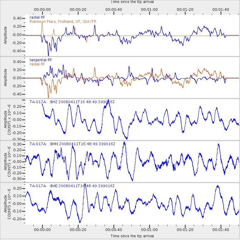
O17A Robinson Place, Fruitland, UT, USA - Earthquake Result Viewer
*The percent match for this event was below the threshold and hence no stack was calculated.
| Earthquake location: |
Loyalty Islands |
| Earthquake latitude/longitude: |
-20.4/168.8 |
| Earthquake time(UTC): |
2008/04/11 (102) 16:35:57 GMT |
| Earthquake Depth: |
35 km |
| Earthquake Magnitude: |
5.6 MS, 5.4 MB, 5.9 MW, 5.9 MW |
| Earthquake Catalog/Contributor: |
WHDF/NEIC |
|
| Network: |
TA USArray Transportable Network (new EarthScope stations) |
| Station: |
O17A Robinson Place, Fruitland, UT, USA |
| Lat/Lon: |
40.19 N/110.74 W |
| Elevation: |
2079 m |
|
| Distance: |
96.0 deg |
| Az: |
49.42 deg |
| Baz: |
248.435 deg |
| Ray Param: |
$rayparam |
*The percent match for this event was below the threshold and hence was not used in the summary stack. |
|
| Radial Match: |
54.80205 % |
| Radial Bump: |
400 |
| Transverse Match: |
62.926758 % |
| Transverse Bump: |
400 |
| SOD ConfigId: |
2504 |
| Insert Time: |
2010-03-06 15:07:31.132 +0000 |
| GWidth: |
2.5 |
| Max Bumps: |
400 |
| Tol: |
0.001 |
|
Signal To Noise
| Channel | StoN | STA | LTA |
| TA:O17A: :BHN:20080411T16:48:49.399016Z | 1.3865714 | 1.2794558E-7 | 9.2274796E-8 |
| TA:O17A: :BHE:20080411T16:48:49.399016Z | 0.82036626 | 1.0089051E-7 | 1.2298227E-7 |
| TA:O17A: :BHZ:20080411T16:48:49.399016Z | 1.4306068 | 1.6059037E-7 | 1.1225332E-7 |
| Arrivals |
| Ps | |
| PpPs | |
| PsPs/PpSs | |


